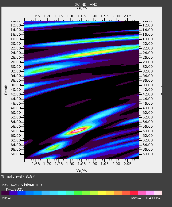
INDI Punta Indio, Guanacaste - Earthquake Result Viewer

Earthquake location: Jujuy Province, Argentina
Earthquake latitude/longitude: -23.1/-66.7
Earthquake time(UTC): 2015/02/11 (042) 18:57:22 GMT
Earthquake Depth: 223 km
Earthquake Magnitude: 6.7 MWW, 6.7 MWC, 6.7 MWB, 6.9 MI
Earthquake Catalog/Contributor: NEIC PDE/NEIC COMCAT
Network: OV Observatorio Vulcanol¿gico y Sismol¿gico de Costa Rica
Station: INDI Punta Indio, Guanacaste
Lat/Lon: 9.87 N/85.50 W
Elevation: 74 m
Distance: 37.6 deg
Az: 328.609 deg
Baz: 150.877 deg
Ray Param: 0.07518583
Estimated Moho Depth: 57.5 km
Estimated Crust Vp/Vs: 1.83
Assumed Crust Vp: 6.183 km/s
Estimated Crust Vs: 3.374 km/s
Estimated Crust Poisson's Ratio: 0.29
Radial Match: 87.3187 %
Radial Bump: 392
Transverse Match: 67.47894 %
Transverse Bump: 400
SOD ConfigId: 7019011
Insert Time: 2019-04-16 18:14:25.851 +0000
GWidth: 2.5
Max Bumps: 400
Tol: 0.001

Signal To Noise

ChannelStoNSTALTA
OV:INDI: :HHZ:20150211T19:03:44.644988Z47.6448755.9192E-61.2423581E-7
OV:INDI: :HHN:20150211T19:03:44.644988Z11.2991062.2191464E-61.9640018E-7
OV:INDI: :HHE:20150211T19:03:44.644988Z13.8374521.7008725E-61.2291804E-7
Arrivals
Ps8.3 SECOND
PpPs25 SECOND
PsPs/PpSs33 SECOND