You are here: Home > Network List > AK - Alaska Regional Network Stations List
> Station MLY Manley Hot Springs, Alaska, USA > Earthquake Result Viewer
MLY Manley Hot Springs, Alaska, USA - Earthquake Result Viewer
| Earthquake location: |
Guerrero, Mexico |
| Earthquake latitude/longitude: |
17.6/-100.8 |
| Earthquake time(UTC): |
2014/04/18 (108) 14:27:26 GMT |
| Earthquake Depth: |
24 km |
| Earthquake Magnitude: |
7.2 MWW, 7.0 MWB, 7.3 MWC, 7.5 MI |
| Earthquake Catalog/Contributor: |
NEIC PDE/NEIC COMCAT |
|
| Network: |
AK Alaska Regional Network |
| Station: |
MLY Manley Hot Springs, Alaska, USA |
| Lat/Lon: |
65.03 N/150.74 W |
| Elevation: |
804 m |
|
| Distance: |
57.9 deg |
| Az: |
337.443 deg |
| Baz: |
120.436 deg |
| Ray Param: |
0.06319237 |
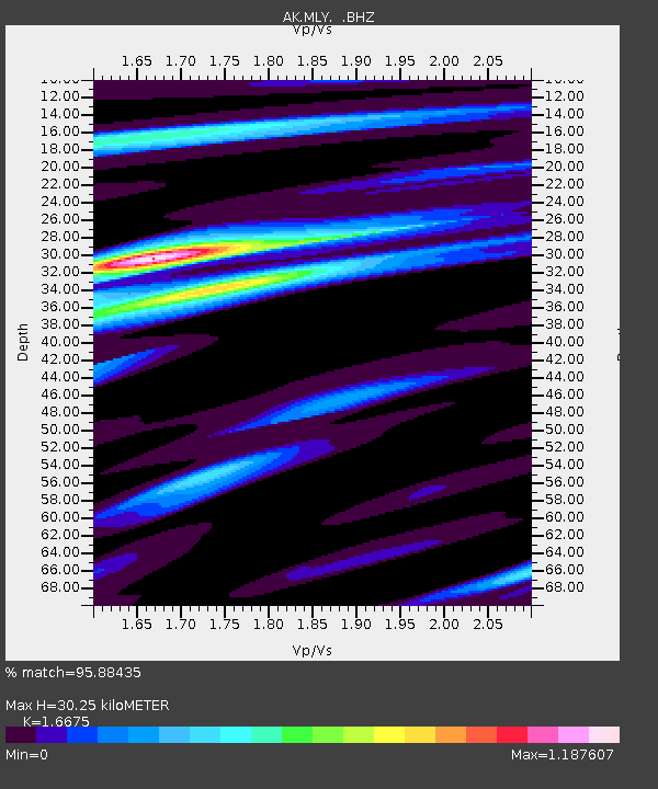
| Estimated Moho Depth: |
30.25 km |
| Estimated Crust Vp/Vs: |
1.67 |
| Assumed Crust Vp: |
6.566 km/s |
| Estimated Crust Vs: |
3.938 km/s |
| Estimated Crust Poisson's Ratio: |
0.22 |
|
| Radial Match: |
95.88435 % |
| Radial Bump: |
243 |
| Transverse Match: |
94.23985 % |
| Transverse Bump: |
269 |
| SOD ConfigId: |
626651 |
| Insert Time: |
2014-05-02 14:40:02.923 +0000 |
| GWidth: |
2.5 |
| Max Bumps: |
400 |
| Tol: |
0.001 |
|

Signal To Noise
| Channel | StoN | STA | LTA |
| AK:MLY: :BHZ:20140418T14:36:45.26802Z | 133.33327 | 1.4957864E-5 | 1.1218403E-7 |
| AK:MLY: :BHN:20140418T14:36:45.26802Z | 9.24288 | 8.693252E-7 | 9.4053505E-8 |
| AK:MLY: :BHE:20140418T14:36:45.26802Z | 84.437675 | 6.9462294E-6 | 8.226458E-8 |
| Arrivals |
| Ps | 3.2 SECOND |
| PpPs | 12 SECOND |
| PsPs/PpSs | 15 SECOND |


