You are here: Home > Network List > AK - Alaska Regional Network Stations List
> Station SCM Sheep Mountain > Earthquake Result Viewer
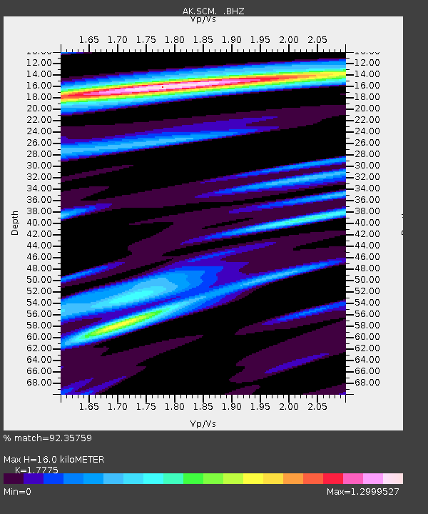
SCM Sheep Mountain - Earthquake Result Viewer
| Earthquake location: |
Guerrero, Mexico |
| Earthquake latitude/longitude: |
17.6/-100.8 |
| Earthquake time(UTC): |
2014/04/18 (108) 14:27:26 GMT |
| Earthquake Depth: |
24 km |
| Earthquake Magnitude: |
7.2 MWW, 7.0 MWB, 7.3 MWC, 7.5 MI |
| Earthquake Catalog/Contributor: |
NEIC PDE/NEIC COMCAT |
|
| Network: |
AK Alaska Regional Network |
| Station: |
SCM Sheep Mountain |
| Lat/Lon: |
61.83 N/147.33 W |
| Elevation: |
1056 m |
|
| Distance: |
54.9 deg |
| Az: |
335.107 deg |
| Baz: |
122.191 deg |
| Ray Param: |
0.06513316 |
| Estimated Moho Depth: |
16.0 km |
| Estimated Crust Vp/Vs: |
1.78 |
| Assumed Crust Vp: |
6.566 km/s |
| Estimated Crust Vs: |
3.694 km/s |
| Estimated Crust Poisson's Ratio: |
0.27 |
|
| Radial Match: |
92.35759 % |
| Radial Bump: |
400 |
| Transverse Match: |
76.42956 % |
| Transverse Bump: |
400 |
| SOD ConfigId: |
626651 |
| Insert Time: |
2014-05-02 14:41:04.294 +0000 |
| GWidth: |
2.5 |
| Max Bumps: |
400 |
| Tol: |
0.001 |
|

Signal To Noise
| Channel | StoN | STA | LTA |
| AK:SCM: :BHZ:20140418T14:36:24.088027Z | 75.388466 | 1.3256308E-5 | 1.7584001E-7 |
| AK:SCM: :BHN:20140418T14:36:24.088027Z | 26.287718 | 3.8941303E-6 | 1.4813497E-7 |
| AK:SCM: :BHE:20140418T14:36:24.088027Z | 32.21406 | 4.8485804E-6 | 1.505113E-7 |
| Arrivals |
| Ps | 2.0 SECOND |
| PpPs | 6.4 SECOND |
| PsPs/PpSs | 8.4 SECOND |


