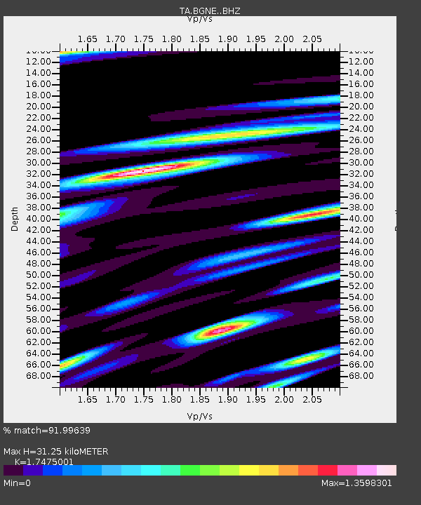
BGNE Belgrade, NE, USA - Earthquake Result Viewer
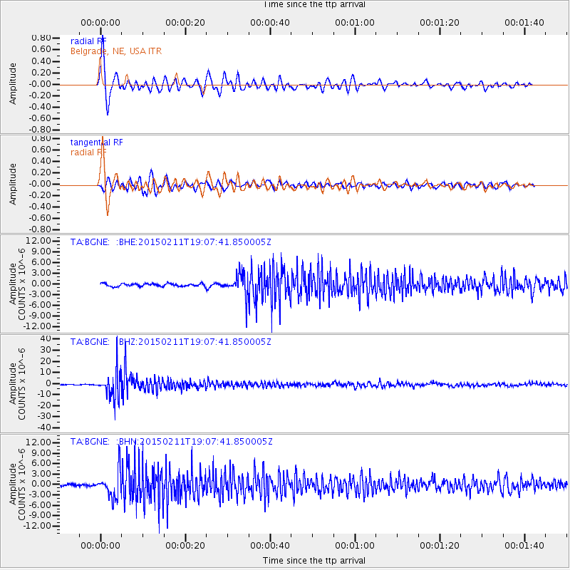
Earthquake location: Jujuy Province, Argentina
Earthquake latitude/longitude: -23.1/-66.7
Earthquake time(UTC): 2015/02/11 (042) 18:57:22 GMT
Earthquake Depth: 223 km
Earthquake Magnitude: 6.7 MWW, 6.7 MWC, 6.7 MWB, 6.9 MI
Earthquake Catalog/Contributor: NEIC PDE/NEIC COMCAT
Network: TA USArray Transportable Network (new EarthScope stations)
Station: BGNE Belgrade, NE, USA
Lat/Lon: 41.41 N/98.15 W
Elevation: 573 m
Distance: 70.5 deg
Az: 335.39 deg
Baz: 149.354 deg
Ray Param: 0.054312464
Estimated Moho Depth: 31.25 km
Estimated Crust Vp/Vs: 1.75
Assumed Crust Vp: 6.53 km/s
Estimated Crust Vs: 3.737 km/s
Estimated Crust Poisson's Ratio: 0.26
Radial Match: 91.99639 %
Radial Bump: 400
Transverse Match: 84.403625 %
Transverse Bump: 400
SOD ConfigId: 7019011
Insert Time: 2019-04-16 18:15:46.015 +0000
GWidth: 2.5
Max Bumps: 400
Tol: 0.001

Signal To Noise

ChannelStoNSTALTA
TA:BGNE: :BHZ:20150211T19:07:41.850005Z45.0101621.2196887E-52.7098073E-7
TA:BGNE: :BHN:20150211T19:07:41.850005Z9.52833753.9886636E-64.1861065E-7
TA:BGNE: :BHE:20150211T19:07:41.850005Z7.95258673.1122502E-63.9135068E-7
Arrivals
Ps3.7 SECOND
PpPs13 SECOND
PsPs/PpSs16 SECOND