You are here: Home > Network List > TA - USArray Transportable Network (new EarthScope stations) Stations List
> Station E57A Chemin Saint Guillaume, Saint Donat, QC, CAN > Earthquake Result Viewer
E57A Chemin Saint Guillaume, Saint Donat, QC, CAN - Earthquake Result Viewer
| Earthquake location: |
Jujuy Province, Argentina |
| Earthquake latitude/longitude: |
-23.1/-66.7 |
| Earthquake time(UTC): |
2015/02/11 (042) 18:57:22 GMT |
| Earthquake Depth: |
223 km |
| Earthquake Magnitude: |
6.7 MWW, 6.7 MWC, 6.7 MWB, 6.9 MI |
| Earthquake Catalog/Contributor: |
NEIC PDE/NEIC COMCAT |
|
| Network: |
TA USArray Transportable Network (new EarthScope stations) |
| Station: |
E57A Chemin Saint Guillaume, Saint Donat, QC, CAN |
| Lat/Lon: |
46.41 N/74.15 W |
| Elevation: |
572 m |
|
| Distance: |
69.5 deg |
| Az: |
354.5 deg |
| Baz: |
172.672 deg |
| Ray Param: |
0.054952487 |
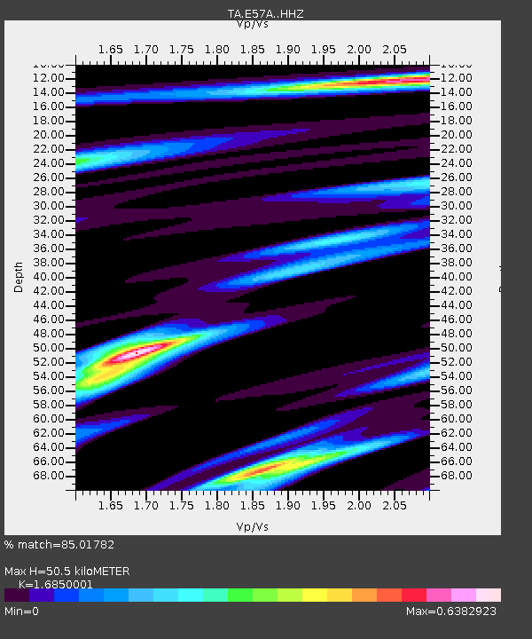
| Estimated Moho Depth: |
50.5 km |
| Estimated Crust Vp/Vs: |
1.69 |
| Assumed Crust Vp: |
6.61 km/s |
| Estimated Crust Vs: |
3.923 km/s |
| Estimated Crust Poisson's Ratio: |
0.23 |
|
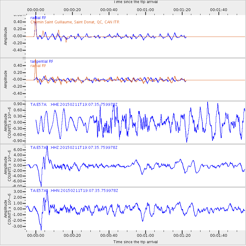
| Radial Match: |
85.01782 % |
| Radial Bump: |
370 |
| Transverse Match: |
45.371487 % |
| Transverse Bump: |
400 |
| SOD ConfigId: |
7019011 |
| Insert Time: |
2019-04-16 18:15:57.952 +0000 |
| GWidth: |
2.5 |
| Max Bumps: |
400 |
| Tol: |
0.001 |
|
Signal To Noise
| Channel | StoN | STA | LTA |
| TA:E57A: :HHZ:20150211T19:07:35.759978Z | 13.37207 | 3.3430144E-6 | 2.4999977E-7 |
| TA:E57A: :HHN:20150211T19:07:35.759978Z | 4.162938 | 1.5511597E-6 | 3.7261177E-7 |
| TA:E57A: :HHE:20150211T19:07:35.759978Z | 0.7875702 | 2.7825172E-7 | 3.5330402E-7 |
| Arrivals |
| Ps | 5.5 SECOND |
| PpPs | 20 SECOND |
| PsPs/PpSs | 25 SECOND |


