You are here: Home > Network List > CI - Caltech Regional Seismic Network Stations List
> Station BAK BAK, Bakersfield, CA, USA > Earthquake Result Viewer
BAK BAK, Bakersfield, CA, USA - Earthquake Result Viewer
| Earthquake location: |
Santa Cruz Islands Region |
| Earthquake latitude/longitude: |
-12.8/169.5 |
| Earthquake time(UTC): |
2002/01/31 (031) 16:27:19 GMT |
| Earthquake Depth: |
667 km |
| Earthquake Magnitude: |
5.3 MB, 5.8 MW, 5.7 MW |
| Earthquake Catalog/Contributor: |
WHDF/NEIC |
|
| Network: |
CI Caltech Regional Seismic Network |
| Station: |
BAK BAK, Bakersfield, CA, USA |
| Lat/Lon: |
35.34 N/119.10 W |
| Elevation: |
116 m |
|
| Distance: |
82.6 deg |
| Az: |
51.36 deg |
| Baz: |
248.751 deg |
| Ray Param: |
0.04467064 |
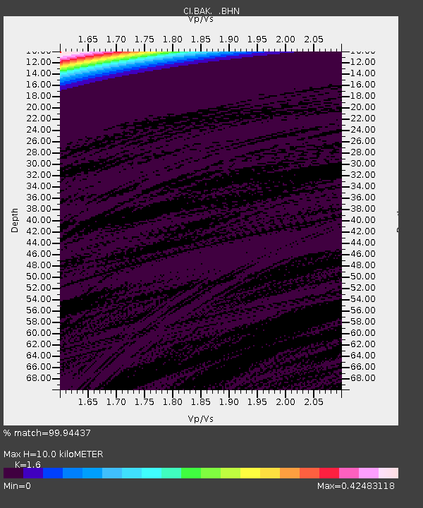
| Estimated Moho Depth: |
10.0 km |
| Estimated Crust Vp/Vs: |
1.60 |
| Assumed Crust Vp: |
6.1 km/s |
| Estimated Crust Vs: |
3.812 km/s |
| Estimated Crust Poisson's Ratio: |
0.18 |
|
| Radial Match: |
99.94437 % |
| Radial Bump: |
2 |
| Transverse Match: |
99.94439 % |
| Transverse Bump: |
2 |
| SOD ConfigId: |
3770 |
| Insert Time: |
2010-02-25 21:01:24.249 +0000 |
| GWidth: |
2.5 |
| Max Bumps: |
400 |
| Tol: |
0.001 |
|
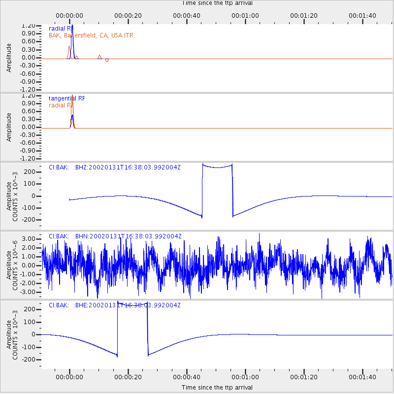
Signal To Noise
| Channel | StoN | STA | LTA |
| CI:BAK: :BHN:20020131T16:38:03.992004Z | 1.1226423 | 1.5559781E-6 | 1.3859964E-6 |
| CI:BAK: :BHE:20020131T16:38:03.992004Z | 2.926295 | 0.029229166 | 0.009988455 |
| CI:BAK: :BHZ:20020131T16:38:03.992004Z | 3.5895503 | 0.0360745 | 0.0100498665 |
| Arrivals |
| Ps | 1.0 SECOND |
| PpPs | 4.2 SECOND |
| PsPs/PpSs | 5.2 SECOND |


