G57A Newington, ON, CAN - Earthquake Result Viewer
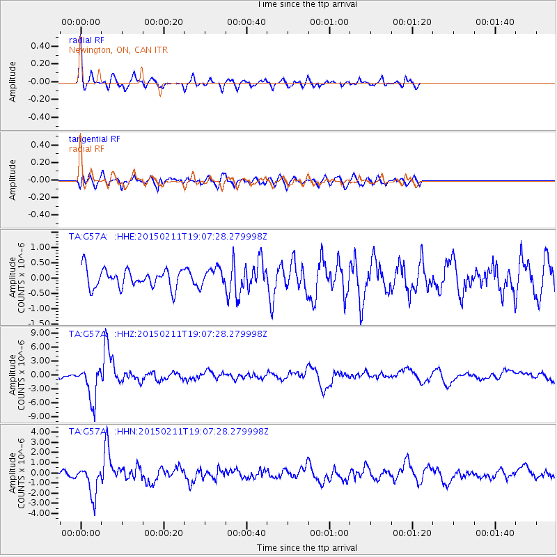
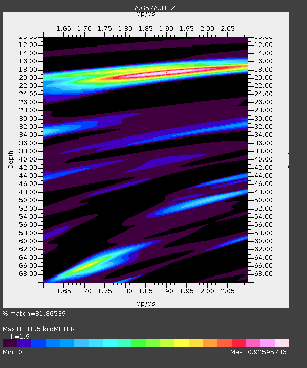
Earthquake location: Jujuy Province, Argentina
Earthquake latitude/longitude: -23.1/-66.7
Earthquake time(UTC): 2015/02/11 (042) 18:57:22 GMT
Earthquake Depth: 223 km
Earthquake Magnitude: 6.7 MWW, 6.7 MWC, 6.7 MWB, 6.9 MI
Earthquake Catalog/Contributor: NEIC PDE/NEIC COMCAT
Network: TA USArray Transportable Network (new EarthScope stations)
Station: G57A Newington, ON, CAN
Lat/Lon: 45.10 N/74.99 W
Elevation: 96 m
Distance: 68.3 deg
Az: 353.687 deg
Baz: 171.781 deg
Ray Param: 0.05574911
Estimated Moho Depth: 18.5 km
Estimated Crust Vp/Vs: 1.90
Assumed Crust Vp: 6.419 km/s
Estimated Crust Vs: 3.379 km/s
Estimated Crust Poisson's Ratio: 0.31
Radial Match: 81.86539 %
Radial Bump: 383
Transverse Match: 62.357414 %
Transverse Bump: 400
SOD ConfigId: 7019011
Insert Time: 2019-04-16 18:16:12.184 +0000
GWidth: 2.5
Max Bumps: 400
Tol: 0.001

Signal To Noise

ChannelStoNSTALTA
TA:G57A: :HHZ:20150211T19:07:28.279998Z6.3093723.7924265E-66.010783E-7
TA:G57A: :HHN:20150211T19:07:28.279998Z4.1006761.5166596E-63.6985602E-7
TA:G57A: :HHE:20150211T19:07:28.279998Z0.9063432.779596E-73.066826E-7
Arrivals
Ps2.7 SECOND
PpPs8.1 SECOND
PsPs/PpSs11 SECOND