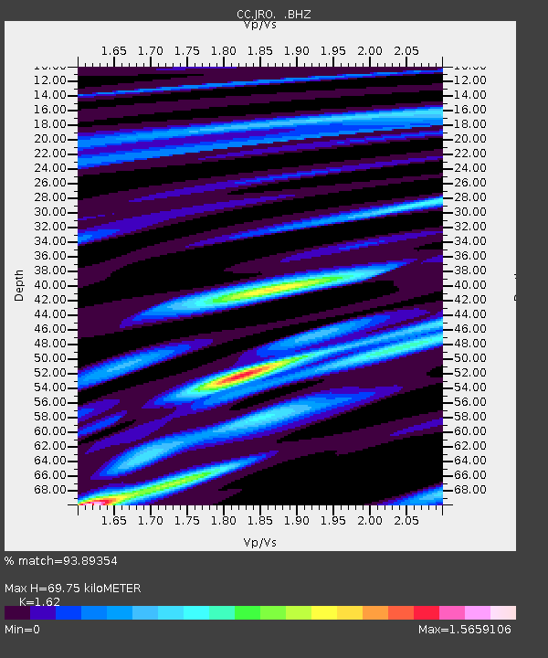
JRO Johnston Ridge Observatory - Earthquake Result Viewer

Earthquake location: Guerrero, Mexico
Earthquake latitude/longitude: 17.6/-100.8
Earthquake time(UTC): 2014/04/18 (108) 14:27:26 GMT
Earthquake Depth: 24 km
Earthquake Magnitude: 7.2 MWW, 7.0 MWB, 7.3 MWC, 7.5 MI
Earthquake Catalog/Contributor: NEIC PDE/NEIC COMCAT
Network: CC Cascade Chain Volcano Monitoring
Station: JRO Johnston Ridge Observatory
Lat/Lon: 46.28 N/122.22 W
Elevation: 1280 m
Distance: 33.7 deg
Az: 332.855 deg
Baz: 141.132 deg
Ray Param: 0.07805848
Estimated Moho Depth: 69.75 km
Estimated Crust Vp/Vs: 1.62
Assumed Crust Vp: 6.566 km/s
Estimated Crust Vs: 4.053 km/s
Estimated Crust Poisson's Ratio: 0.19
Radial Match: 93.89354 %
Radial Bump: 381
Transverse Match: 86.425354 %
Transverse Bump: 400
SOD ConfigId: 626651
Insert Time: 2014-05-02 14:44:53.421 +0000
GWidth: 2.5
Max Bumps: 400
Tol: 0.001

Signal To Noise

ChannelStoNSTALTA
CC:JRO: :BHZ:20140418T14:33:35.139999Z64.5361.4327318E-52.2200503E-7
CC:JRO: :BHN:20140418T14:33:35.139999Z32.0615166.547408E-62.0421393E-7
CC:JRO: :BHE:20140418T14:33:35.139999Z27.9208357.4991453E-62.68586E-7
Arrivals
Ps7.2 SECOND
PpPs25 SECOND
PsPs/PpSs33 SECOND