You are here: Home > Network List > TA - USArray Transportable Network (new EarthScope stations) Stations List
> Station J01E Myrtle Point, OR, USA > Earthquake Result Viewer
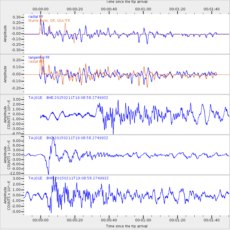
J01E Myrtle Point, OR, USA - Earthquake Result Viewer
*The percent match for this event was below the threshold and hence no stack was calculated.
| Earthquake location: |
Jujuy Province, Argentina |
| Earthquake latitude/longitude: |
-23.1/-66.7 |
| Earthquake time(UTC): |
2015/02/11 (042) 18:57:22 GMT |
| Earthquake Depth: |
223 km |
| Earthquake Magnitude: |
6.7 MWW, 6.7 MWC, 6.7 MWB, 6.9 MI |
| Earthquake Catalog/Contributor: |
NEIC PDE/NEIC COMCAT |
|
| Network: |
TA USArray Transportable Network (new EarthScope stations) |
| Station: |
J01E Myrtle Point, OR, USA |
| Lat/Lon: |
43.16 N/123.93 W |
| Elevation: |
128 m |
|
| Distance: |
84.3 deg |
| Az: |
321.804 deg |
| Baz: |
128.916 deg |
| Ray Param: |
$rayparam |
*The percent match for this event was below the threshold and hence was not used in the summary stack. |
|
| Radial Match: |
77.38829 % |
| Radial Bump: |
400 |
| Transverse Match: |
70.431595 % |
| Transverse Bump: |
400 |
| SOD ConfigId: |
7019011 |
| Insert Time: |
2019-04-16 18:16:40.325 +0000 |
| GWidth: |
2.5 |
| Max Bumps: |
400 |
| Tol: |
0.001 |
|
Signal To Noise
| Channel | StoN | STA | LTA |
| TA:J01E: :BHZ:20150211T19:08:58.274993Z | 8.142391 | 4.855314E-6 | 5.9630077E-7 |
| TA:J01E: :BHN:20150211T19:08:58.274993Z | 1.5897967 | 7.6996236E-7 | 4.8431497E-7 |
| TA:J01E: :BHE:20150211T19:08:58.274993Z | 2.7789197 | 1.1391417E-6 | 4.0992248E-7 |
| Arrivals |
| Ps | |
| PpPs | |
| PsPs/PpSs | |


