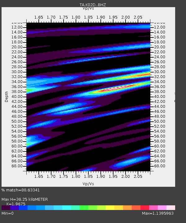
K02D Willamette Meridian, OR, USA - Earthquake Result Viewer
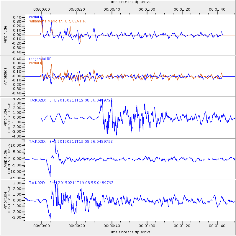
Earthquake location: Jujuy Province, Argentina
Earthquake latitude/longitude: -23.1/-66.7
Earthquake time(UTC): 2015/02/11 (042) 18:57:22 GMT
Earthquake Depth: 223 km
Earthquake Magnitude: 6.7 MWW, 6.7 MWC, 6.7 MWB, 6.9 MI
Earthquake Catalog/Contributor: NEIC PDE/NEIC COMCAT
Network: TA USArray Transportable Network (new EarthScope stations)
Station: K02D Willamette Meridian, OR, USA
Lat/Lon: 42.70 N/123.67 W
Elevation: 989 m
Distance: 83.9 deg
Az: 321.564 deg
Baz: 129.072 deg
Ray Param: 0.04532017
Estimated Moho Depth: 36.25 km
Estimated Crust Vp/Vs: 1.97
Assumed Crust Vp: 6.522 km/s
Estimated Crust Vs: 3.315 km/s
Estimated Crust Poisson's Ratio: 0.33
Radial Match: 88.63341 %
Radial Bump: 400
Transverse Match: 77.91564 %
Transverse Bump: 400
SOD ConfigId: 7019011
Insert Time: 2019-04-16 18:16:50.652 +0000
GWidth: 2.5
Max Bumps: 400
Tol: 0.001

Signal To Noise

ChannelStoNSTALTA
TA:K02D: :BHZ:20150211T19:08:56.048979Z10.3106894.7531735E-64.6099476E-7
TA:K02D: :BHN:20150211T19:08:56.048979Z4.2992231.1413345E-62.654746E-7
TA:K02D: :BHE:20150211T19:08:56.048979Z2.97252081.419241E-64.774536E-7
Arrivals
Ps5.5 SECOND
PpPs16 SECOND
PsPs/PpSs22 SECOND