You are here: Home > Network List > CN - Canadian National Seismograph Network Stations List
> Station PNPO PUKASKWA, ON > Earthquake Result Viewer
PNPO PUKASKWA, ON - Earthquake Result Viewer
| Earthquake location: |
Guerrero, Mexico |
| Earthquake latitude/longitude: |
17.6/-100.8 |
| Earthquake time(UTC): |
2014/04/18 (108) 14:27:26 GMT |
| Earthquake Depth: |
24 km |
| Earthquake Magnitude: |
7.2 MWW, 7.0 MWB, 7.3 MWC, 7.5 MI |
| Earthquake Catalog/Contributor: |
NEIC PDE/NEIC COMCAT |
|
| Network: |
CN Canadian National Seismograph Network |
| Station: |
PNPO PUKASKWA, ON |
| Lat/Lon: |
48.60 N/86.28 W |
| Elevation: |
219 m |
|
| Distance: |
33.2 deg |
| Az: |
17.734 deg |
| Baz: |
205.96 deg |
| Ray Param: |
0.07830888 |
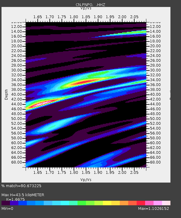
| Estimated Moho Depth: |
43.5 km |
| Estimated Crust Vp/Vs: |
1.67 |
| Assumed Crust Vp: |
6.472 km/s |
| Estimated Crust Vs: |
3.881 km/s |
| Estimated Crust Poisson's Ratio: |
0.22 |
|
| Radial Match: |
90.673225 % |
| Radial Bump: |
311 |
| Transverse Match: |
77.0794 % |
| Transverse Bump: |
400 |
| SOD ConfigId: |
626651 |
| Insert Time: |
2014-05-02 14:47:43.284 +0000 |
| GWidth: |
2.5 |
| Max Bumps: |
400 |
| Tol: |
0.001 |
|

Signal To Noise
| Channel | StoN | STA | LTA |
| CN:PNPO: :HHZ:20140418T14:33:30.400009Z | 55.19109 | 3.0211238E-6 | 5.473934E-8 |
| CN:PNPO: :HHN:20140418T14:33:30.400009Z | 28.563026 | 1.5964885E-6 | 5.5893533E-8 |
| CN:PNPO: :HHE:20140418T14:33:30.400009Z | 28.105684 | 1.0175762E-6 | 3.6205353E-8 |
| Arrivals |
| Ps | 4.9 SECOND |
| PpPs | 16 SECOND |
| PsPs/PpSs | 21 SECOND |


