You are here: Home > Network List > CN - Canadian National Seismograph Network Stations List
> Station VIB VAN INLET, BC > Earthquake Result Viewer
VIB VAN INLET, BC - Earthquake Result Viewer
| Earthquake location: |
Guerrero, Mexico |
| Earthquake latitude/longitude: |
17.6/-100.8 |
| Earthquake time(UTC): |
2014/04/18 (108) 14:27:26 GMT |
| Earthquake Depth: |
24 km |
| Earthquake Magnitude: |
7.2 MWW, 7.0 MWB, 7.3 MWC, 7.5 MI |
| Earthquake Catalog/Contributor: |
NEIC PDE/NEIC COMCAT |
|
| Network: |
CN Canadian National Seismograph Network |
| Station: |
VIB VAN INLET, BC |
| Lat/Lon: |
53.25 N/132.54 W |
| Elevation: |
1008 m |
|
| Distance: |
43.3 deg |
| Az: |
332.594 deg |
| Baz: |
133.045 deg |
| Ray Param: |
0.07257023 |
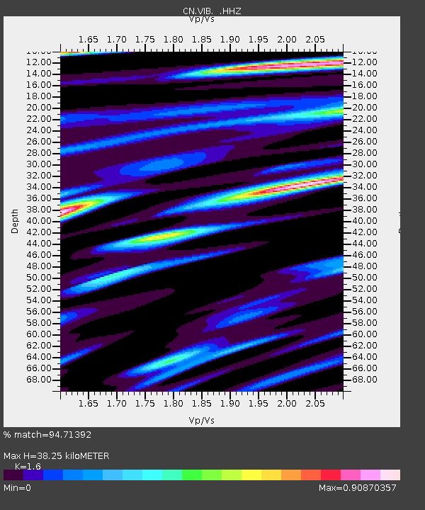
| Estimated Moho Depth: |
38.25 km |
| Estimated Crust Vp/Vs: |
1.60 |
| Assumed Crust Vp: |
6.183 km/s |
| Estimated Crust Vs: |
3.864 km/s |
| Estimated Crust Poisson's Ratio: |
0.18 |
|
| Radial Match: |
94.71392 % |
| Radial Bump: |
400 |
| Transverse Match: |
80.11909 % |
| Transverse Bump: |
400 |
| SOD ConfigId: |
626651 |
| Insert Time: |
2014-05-02 14:48:12.912 +0000 |
| GWidth: |
2.5 |
| Max Bumps: |
400 |
| Tol: |
0.001 |
|
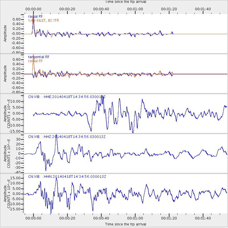
Signal To Noise
| Channel | StoN | STA | LTA |
| CN:VIB: :HHZ:20140418T14:34:56.030013Z | 26.276943 | 1.2776277E-5 | 4.8621627E-7 |
| CN:VIB: :HHN:20140418T14:34:56.030013Z | 6.9363685 | 5.010288E-6 | 7.223215E-7 |
| CN:VIB: :HHE:20140418T14:34:56.030013Z | 8.578565 | 6.810295E-6 | 7.938735E-7 |
| Arrivals |
| Ps | 4.0 SECOND |
| PpPs | 15 SECOND |
| PsPs/PpSs | 19 SECOND |


