You are here: Home > Network List > TA - USArray Transportable Network (new EarthScope stations) Stations List
> Station L56A Greenwood, NY, USA > Earthquake Result Viewer
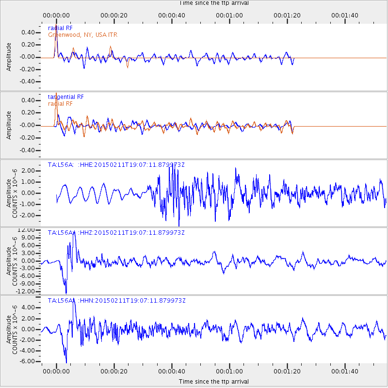
L56A Greenwood, NY, USA - Earthquake Result Viewer
*The percent match for this event was below the threshold and hence no stack was calculated.
| Earthquake location: |
Jujuy Province, Argentina |
| Earthquake latitude/longitude: |
-23.1/-66.7 |
| Earthquake time(UTC): |
2015/02/11 (042) 18:57:22 GMT |
| Earthquake Depth: |
223 km |
| Earthquake Magnitude: |
6.7 MWW, 6.7 MWC, 6.7 MWB, 6.9 MI |
| Earthquake Catalog/Contributor: |
NEIC PDE/NEIC COMCAT |
|
| Network: |
TA USArray Transportable Network (new EarthScope stations) |
| Station: |
L56A Greenwood, NY, USA |
| Lat/Lon: |
42.14 N/77.56 W |
| Elevation: |
688 m |
|
| Distance: |
65.7 deg |
| Az: |
351.148 deg |
| Baz: |
169.018 deg |
| Ray Param: |
$rayparam |
*The percent match for this event was below the threshold and hence was not used in the summary stack. |
|
| Radial Match: |
79.9798 % |
| Radial Bump: |
400 |
| Transverse Match: |
62.138294 % |
| Transverse Bump: |
400 |
| SOD ConfigId: |
7019011 |
| Insert Time: |
2019-04-16 18:17:05.427 +0000 |
| GWidth: |
2.5 |
| Max Bumps: |
400 |
| Tol: |
0.001 |
|
Signal To Noise
| Channel | StoN | STA | LTA |
| TA:L56A: :HHZ:20150211T19:07:11.879973Z | 7.3520756 | 5.096165E-6 | 6.9315996E-7 |
| TA:L56A: :HHN:20150211T19:07:11.879973Z | 6.1725817 | 2.2273275E-6 | 3.6084214E-7 |
| TA:L56A: :HHE:20150211T19:07:11.879973Z | 0.84771055 | 4.100553E-7 | 4.837209E-7 |
| Arrivals |
| Ps | |
| PpPs | |
| PsPs/PpSs | |


