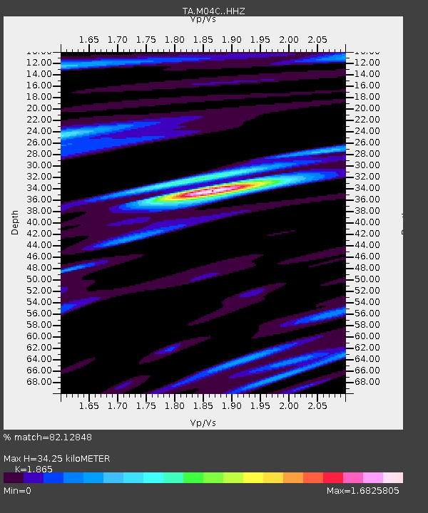
M04C Macdoel, CA, USA - Earthquake Result Viewer

Earthquake location: Jujuy Province, Argentina
Earthquake latitude/longitude: -23.1/-66.7
Earthquake time(UTC): 2015/02/11 (042) 18:57:22 GMT
Earthquake Depth: 223 km
Earthquake Magnitude: 6.7 MWW, 6.7 MWC, 6.7 MWB, 6.9 MI
Earthquake Catalog/Contributor: NEIC PDE/NEIC COMCAT
Network: TA USArray Transportable Network (new EarthScope stations)
Station: M04C Macdoel, CA, USA
Lat/Lon: 41.78 N/121.84 W
Elevation: 1391 m
Distance: 82.3 deg
Az: 321.729 deg
Baz: 130.315 deg
Ray Param: 0.04645432
Estimated Moho Depth: 34.25 km
Estimated Crust Vp/Vs: 1.87
Assumed Crust Vp: 6.566 km/s
Estimated Crust Vs: 3.521 km/s
Estimated Crust Poisson's Ratio: 0.30
Radial Match: 82.12848 %
Radial Bump: 400
Transverse Match: 77.6216 %
Transverse Bump: 400
SOD ConfigId: 7019011
Insert Time: 2019-04-16 18:17:13.910 +0000
GWidth: 2.5
Max Bumps: 400
Tol: 0.001

Signal To Noise

ChannelStoNSTALTA
TA:M04C: :HHZ:20150211T19:08:47.74002Z22.3886264.849683E-62.166137E-7
TA:M04C: :HHN:20150211T19:08:47.74002Z4.48137861.0239739E-62.284953E-7
TA:M04C: :HHE:20150211T19:08:47.74002Z2.02077081.0217177E-65.0560794E-7
Arrivals
Ps4.6 SECOND
PpPs15 SECOND
PsPs/PpSs19 SECOND