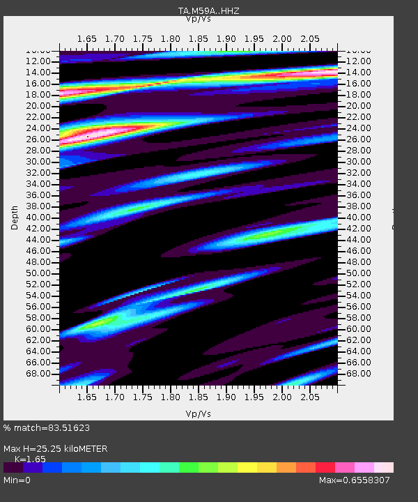
M59A Waymart, PA, USA - Earthquake Result Viewer
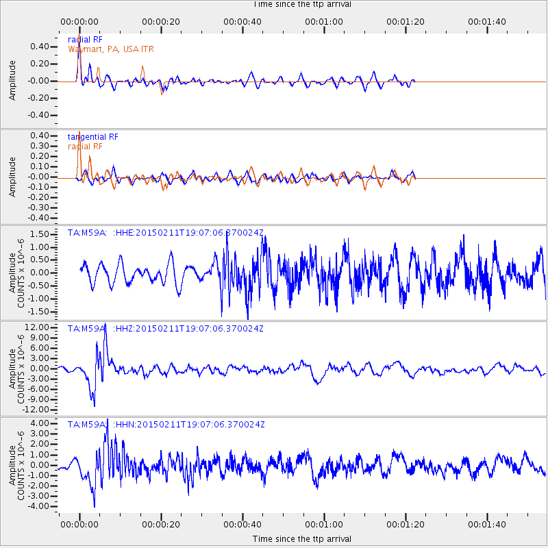
Earthquake location: Jujuy Province, Argentina
Earthquake latitude/longitude: -23.1/-66.7
Earthquake time(UTC): 2015/02/11 (042) 18:57:22 GMT
Earthquake Depth: 223 km
Earthquake Magnitude: 6.7 MWW, 6.7 MWC, 6.7 MWB, 6.9 MI
Earthquake Catalog/Contributor: NEIC PDE/NEIC COMCAT
Network: TA USArray Transportable Network (new EarthScope stations)
Station: M59A Waymart, PA, USA
Lat/Lon: 41.54 N/75.43 W
Elevation: 471 m
Distance: 64.8 deg
Az: 352.758 deg
Baz: 171.106 deg
Ray Param: 0.057992876
Estimated Moho Depth: 25.25 km
Estimated Crust Vp/Vs: 1.65
Assumed Crust Vp: 6.283 km/s
Estimated Crust Vs: 3.808 km/s
Estimated Crust Poisson's Ratio: 0.21
Radial Match: 83.51623 %
Radial Bump: 400
Transverse Match: 65.17242 %
Transverse Bump: 400
SOD ConfigId: 7019011
Insert Time: 2019-04-16 18:17:18.981 +0000
GWidth: 2.5
Max Bumps: 400
Tol: 0.001

Signal To Noise

ChannelStoNSTALTA
TA:M59A: :HHZ:20150211T19:07:06.370024Z9.64543154.584183E-64.7526987E-7
TA:M59A: :HHN:20150211T19:07:06.370024Z4.11781171.5121177E-63.672139E-7
TA:M59A: :HHE:20150211T19:07:06.370024Z1.26325234.6770583E-73.7023946E-7
Arrivals
Ps2.7 SECOND
PpPs10 SECOND
PsPs/PpSs13 SECOND