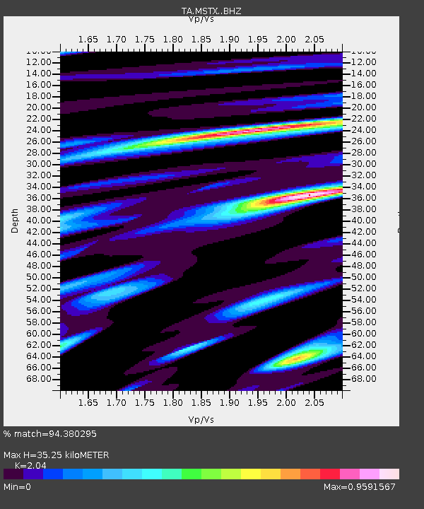
MSTX Muleshoe, TX, USA - Earthquake Result Viewer

Earthquake location: Jujuy Province, Argentina
Earthquake latitude/longitude: -23.1/-66.7
Earthquake time(UTC): 2015/02/11 (042) 18:57:22 GMT
Earthquake Depth: 223 km
Earthquake Magnitude: 6.7 MWW, 6.7 MWC, 6.7 MWB, 6.9 MI
Earthquake Catalog/Contributor: NEIC PDE/NEIC COMCAT
Network: TA USArray Transportable Network (new EarthScope stations)
Station: MSTX Muleshoe, TX, USA
Lat/Lon: 33.97 N/102.77 W
Elevation: 1167 m
Distance: 66.3 deg
Az: 327.698 deg
Baz: 143.699 deg
Ray Param: 0.057014797
Estimated Moho Depth: 35.25 km
Estimated Crust Vp/Vs: 2.04
Assumed Crust Vp: 6.129 km/s
Estimated Crust Vs: 3.004 km/s
Estimated Crust Poisson's Ratio: 0.34
Radial Match: 94.380295 %
Radial Bump: 400
Transverse Match: 78.90755 %
Transverse Bump: 400
SOD ConfigId: 7019011
Insert Time: 2019-04-16 18:17:26.536 +0000
GWidth: 2.5
Max Bumps: 400
Tol: 0.001

Signal To Noise

ChannelStoNSTALTA
TA:MSTX: :BHZ:20150211T19:07:16.100005Z34.4037676.498346E-61.8888473E-7
TA:MSTX: :BHN:20150211T19:07:16.100005Z8.8960652.1630524E-62.431471E-7
TA:MSTX: :BHE:20150211T19:07:16.100005Z6.514881.6849874E-62.5863676E-7
Arrivals
Ps6.2 SECOND
PpPs17 SECOND
PsPs/PpSs23 SECOND