You are here: Home > Network List > G - GEOSCOPE Stations List
> Station IVI Ivittuut, Greenland > Earthquake Result Viewer
IVI Ivittuut, Greenland - Earthquake Result Viewer
| Earthquake location: |
Guerrero, Mexico |
| Earthquake latitude/longitude: |
17.6/-100.8 |
| Earthquake time(UTC): |
2014/04/18 (108) 14:27:26 GMT |
| Earthquake Depth: |
24 km |
| Earthquake Magnitude: |
7.2 MWW, 7.0 MWB, 7.3 MWC, 7.5 MI |
| Earthquake Catalog/Contributor: |
NEIC PDE/NEIC COMCAT |
|
| Network: |
G GEOSCOPE |
| Station: |
IVI Ivittuut, Greenland |
| Lat/Lon: |
61.21 N/48.17 W |
| Elevation: |
15 m |
|
| Distance: |
57.1 deg |
| Az: |
27.266 deg |
| Baz: |
244.521 deg |
| Ray Param: |
0.06364408 |
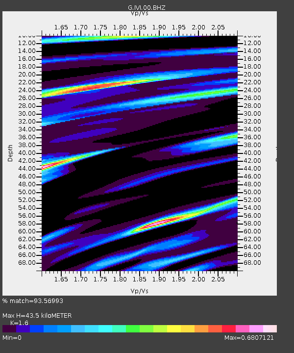
| Estimated Moho Depth: |
43.5 km |
| Estimated Crust Vp/Vs: |
1.60 |
| Assumed Crust Vp: |
6.472 km/s |
| Estimated Crust Vs: |
4.045 km/s |
| Estimated Crust Poisson's Ratio: |
0.18 |
|
| Radial Match: |
93.56993 % |
| Radial Bump: |
400 |
| Transverse Match: |
80.5979 % |
| Transverse Bump: |
400 |
| SOD ConfigId: |
626651 |
| Insert Time: |
2014-05-02 14:49:48.381 +0000 |
| GWidth: |
2.5 |
| Max Bumps: |
400 |
| Tol: |
0.001 |
|
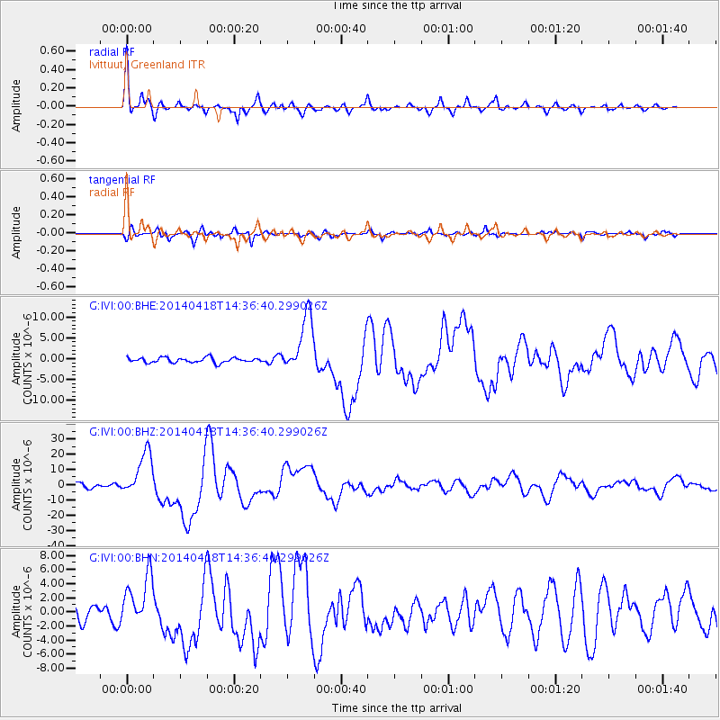
Signal To Noise
| Channel | StoN | STA | LTA |
| G:IVI:00:BHZ:20140418T14:36:40.299026Z | 10.104401 | 1.4939001E-5 | 1.4784647E-6 |
| G:IVI:00:BHN:20140418T14:36:40.299026Z | 2.9726892 | 3.6900908E-6 | 1.2413309E-6 |
| G:IVI:00:BHE:20140418T14:36:40.299026Z | 11.787368 | 6.917464E-6 | 5.86854E-7 |
| Arrivals |
| Ps | 4.3 SECOND |
| PpPs | 17 SECOND |
| PsPs/PpSs | 21 SECOND |


