You are here: Home > Network List > G - GEOSCOPE Stations List
> Station MPG Montagne des Peres, French Guyana > Earthquake Result Viewer
MPG Montagne des Peres, French Guyana - Earthquake Result Viewer
| Earthquake location: |
Guerrero, Mexico |
| Earthquake latitude/longitude: |
17.6/-100.8 |
| Earthquake time(UTC): |
2014/04/18 (108) 14:27:26 GMT |
| Earthquake Depth: |
24 km |
| Earthquake Magnitude: |
7.2 MWW, 7.0 MWB, 7.3 MWC, 7.5 MI |
| Earthquake Catalog/Contributor: |
NEIC PDE/NEIC COMCAT |
|
| Network: |
G GEOSCOPE |
| Station: |
MPG Montagne des Peres, French Guyana |
| Lat/Lon: |
5.11 N/52.64 W |
| Elevation: |
147 m |
|
| Distance: |
48.7 deg |
| Az: |
98.785 deg |
| Baz: |
288.819 deg |
| Ray Param: |
0.06916156 |
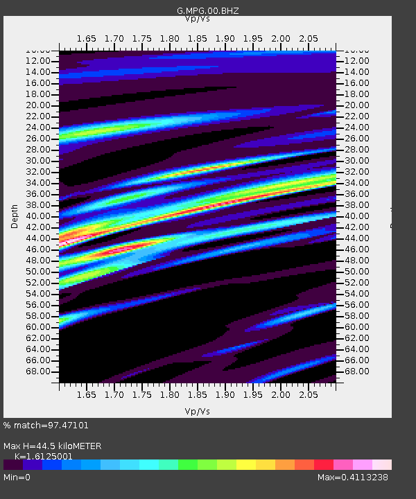
| Estimated Moho Depth: |
44.5 km |
| Estimated Crust Vp/Vs: |
1.61 |
| Assumed Crust Vp: |
6.472 km/s |
| Estimated Crust Vs: |
4.014 km/s |
| Estimated Crust Poisson's Ratio: |
0.19 |
|
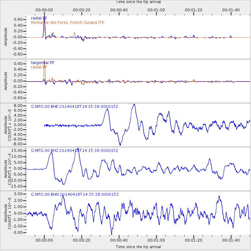
| Radial Match: |
97.47101 % |
| Radial Bump: |
308 |
| Transverse Match: |
88.276306 % |
| Transverse Bump: |
400 |
| SOD ConfigId: |
626651 |
| Insert Time: |
2014-05-02 14:49:55.237 +0000 |
| GWidth: |
2.5 |
| Max Bumps: |
400 |
| Tol: |
0.001 |
|
Signal To Noise
| Channel | StoN | STA | LTA |
| G:MPG:00:BHZ:20140418T14:35:38.000015Z | 36.875984 | 8.096474E-6 | 2.1955952E-7 |
| G:MPG:00:BHN:20140418T14:35:38.000015Z | 7.964788 | 1.3203505E-6 | 1.6577347E-7 |
| G:MPG:00:BHE:20140418T14:35:38.000015Z | 21.555355 | 3.9946954E-6 | 1.8532263E-7 |
| Arrivals |
| Ps | 4.5 SECOND |
| PpPs | 17 SECOND |
| PsPs/PpSs | 21 SECOND |


