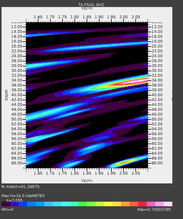
P52A Corning, OH, USA - Earthquake Result Viewer

Earthquake location: Jujuy Province, Argentina
Earthquake latitude/longitude: -23.1/-66.7
Earthquake time(UTC): 2015/02/11 (042) 18:57:22 GMT
Earthquake Depth: 223 km
Earthquake Magnitude: 6.7 MWW, 6.7 MWC, 6.7 MWB, 6.9 MI
Earthquake Catalog/Contributor: NEIC PDE/NEIC COMCAT
Network: TA USArray Transportable Network (new EarthScope stations)
Station: P52A Corning, OH, USA
Lat/Lon: 39.63 N/82.13 W
Elevation: 293 m
Distance: 64.1 deg
Az: 346.783 deg
Baz: 164.18 deg
Ray Param: 0.058489636
Estimated Moho Depth: 34.0 km
Estimated Crust Vp/Vs: 2.06
Assumed Crust Vp: 6.232 km/s
Estimated Crust Vs: 3.032 km/s
Estimated Crust Poisson's Ratio: 0.34
Radial Match: 81.26975 %
Radial Bump: 400
Transverse Match: 65.6301 %
Transverse Bump: 400
SOD ConfigId: 7019011
Insert Time: 2019-04-16 18:17:45.435 +0000
GWidth: 2.5
Max Bumps: 400
Tol: 0.001

Signal To Noise

ChannelStoNSTALTA
TA:P52A: :BHZ:20150211T19:07:01.425017Z8.850384.1350304E-64.6721502E-7
TA:P52A: :BHN:20150211T19:07:01.425017Z6.5607851.9659283E-62.9964835E-7
TA:P52A: :BHE:20150211T19:07:01.425017Z1.74530865.8358364E-73.3437274E-7
Arrivals
Ps6.0 SECOND
PpPs16 SECOND
PsPs/PpSs22 SECOND