You are here: Home > Network List > GB - Great Britain Seismograph Network Stations List
> Station MCH1 MICHAELCHURCH, WALES > Earthquake Result Viewer
MCH1 MICHAELCHURCH, WALES - Earthquake Result Viewer
| Earthquake location: |
Guerrero, Mexico |
| Earthquake latitude/longitude: |
17.6/-100.8 |
| Earthquake time(UTC): |
2014/04/18 (108) 14:27:26 GMT |
| Earthquake Depth: |
24 km |
| Earthquake Magnitude: |
7.2 MWW, 7.0 MWB, 7.3 MWC, 7.5 MI |
| Earthquake Catalog/Contributor: |
NEIC PDE/NEIC COMCAT |
|
| Network: |
GB Great Britain Seismograph Network |
| Station: |
MCH1 MICHAELCHURCH, WALES |
| Lat/Lon: |
52.00 N/3.00 W |
| Elevation: |
219 m |
|
| Distance: |
81.1 deg |
| Az: |
38.32 deg |
| Baz: |
286.908 deg |
| Ray Param: |
0.04782361 |
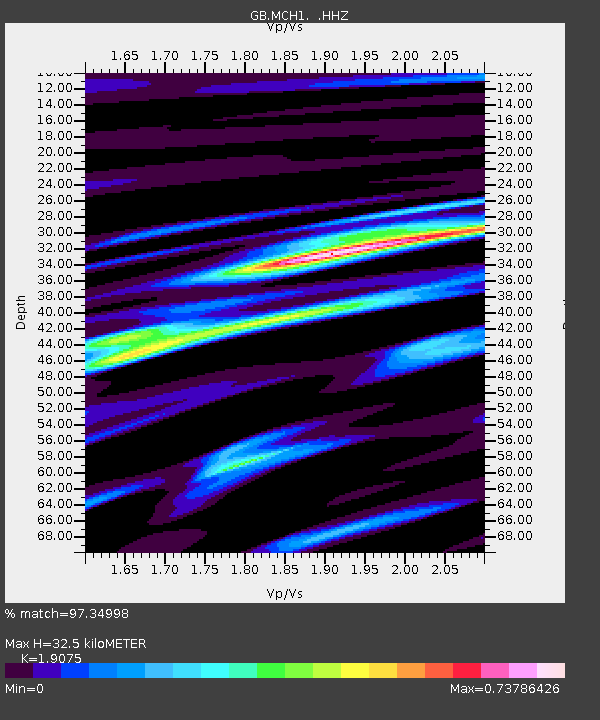
| Estimated Moho Depth: |
32.5 km |
| Estimated Crust Vp/Vs: |
1.91 |
| Assumed Crust Vp: |
6.182 km/s |
| Estimated Crust Vs: |
3.241 km/s |
| Estimated Crust Poisson's Ratio: |
0.31 |
|
| Radial Match: |
97.34998 % |
| Radial Bump: |
337 |
| Transverse Match: |
86.96997 % |
| Transverse Bump: |
400 |
| SOD ConfigId: |
626651 |
| Insert Time: |
2014-05-02 14:51:15.188 +0000 |
| GWidth: |
2.5 |
| Max Bumps: |
400 |
| Tol: |
0.001 |
|

Signal To Noise
| Channel | StoN | STA | LTA |
| GB:MCH1: :HHZ:20140418T14:39:08.229995Z | 24.067465 | 9.551537E-6 | 3.968651E-7 |
| GB:MCH1: :HHN:20140418T14:39:08.229995Z | 2.8214886 | 6.7837743E-7 | 2.4043246E-7 |
| GB:MCH1: :HHE:20140418T14:39:08.229995Z | 9.799727 | 3.2914504E-6 | 3.3587165E-7 |
| Arrivals |
| Ps | 4.9 SECOND |
| PpPs | 15 SECOND |
| PsPs/PpSs | 20 SECOND |


