You are here: Home > Network List > TA - USArray Transportable Network (new EarthScope stations) Stations List
> Station Q58A Fox Den Farm, The Plains, VA, USA > Earthquake Result Viewer
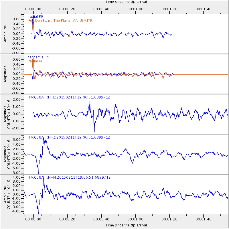
Q58A Fox Den Farm, The Plains, VA, USA - Earthquake Result Viewer
| Earthquake location: |
Jujuy Province, Argentina |
| Earthquake latitude/longitude: |
-23.1/-66.7 |
| Earthquake time(UTC): |
2015/02/11 (042) 18:57:22 GMT |
| Earthquake Depth: |
223 km |
| Earthquake Magnitude: |
6.7 MWW, 6.7 MWC, 6.7 MWB, 6.9 MI |
| Earthquake Catalog/Contributor: |
NEIC PDE/NEIC COMCAT |
|
| Network: |
TA USArray Transportable Network (new EarthScope stations) |
| Station: |
Q58A Fox Den Farm, The Plains, VA, USA |
| Lat/Lon: |
38.94 N/77.68 W |
| Elevation: |
182 m |
|
| Distance: |
62.6 deg |
| Az: |
350.357 deg |
| Baz: |
168.594 deg |
| Ray Param: |
0.059443798 |
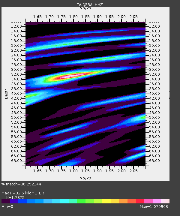
| Estimated Moho Depth: |
32.5 km |
| Estimated Crust Vp/Vs: |
1.79 |
| Assumed Crust Vp: |
6.419 km/s |
| Estimated Crust Vs: |
3.591 km/s |
| Estimated Crust Poisson's Ratio: |
0.27 |
|
| Radial Match: |
86.252144 % |
| Radial Bump: |
400 |
| Transverse Match: |
65.061714 % |
| Transverse Bump: |
400 |
| SOD ConfigId: |
7019011 |
| Insert Time: |
2019-04-16 18:17:55.859 +0000 |
| GWidth: |
2.5 |
| Max Bumps: |
400 |
| Tol: |
0.001 |
|
Signal To Noise
| Channel | StoN | STA | LTA |
| TA:Q58A: :HHZ:20150211T19:06:51.689971Z | 7.736907 | 3.069258E-6 | 3.9670346E-7 |
| TA:Q58A: :HHN:20150211T19:06:51.689971Z | 5.288154 | 1.7422519E-6 | 3.2946315E-7 |
| TA:Q58A: :HHE:20150211T19:06:51.689971Z | 2.2604566 | 5.6333437E-7 | 2.4921266E-7 |
| Arrivals |
| Ps | 4.2 SECOND |
| PpPs | 14 SECOND |
| PsPs/PpSs | 18 SECOND |


