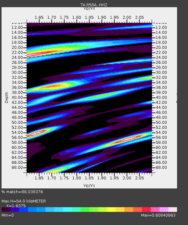
R58A Rapidan, VA, USA - Earthquake Result Viewer
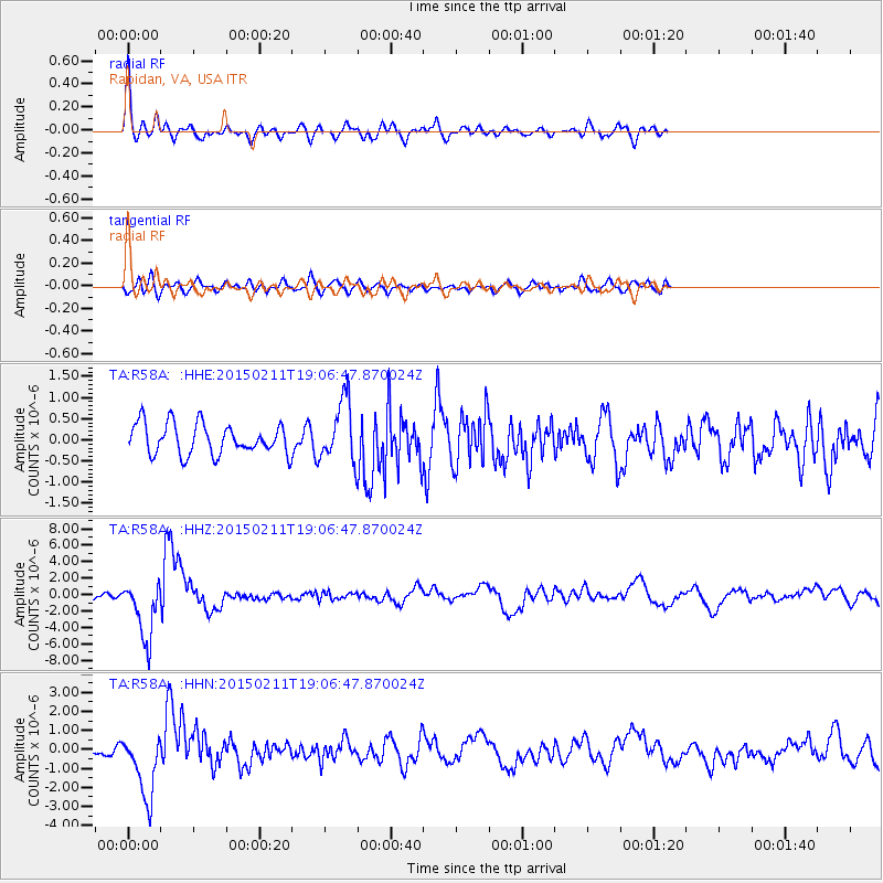
Earthquake location: Jujuy Province, Argentina
Earthquake latitude/longitude: -23.1/-66.7
Earthquake time(UTC): 2015/02/11 (042) 18:57:22 GMT
Earthquake Depth: 223 km
Earthquake Magnitude: 6.7 MWW, 6.7 MWC, 6.7 MWB, 6.9 MI
Earthquake Catalog/Contributor: NEIC PDE/NEIC COMCAT
Network: TA USArray Transportable Network (new EarthScope stations)
Station: R58A Rapidan, VA, USA
Lat/Lon: 38.30 N/78.00 W
Elevation: 184 m
Distance: 62.0 deg
Az: 349.933 deg
Baz: 168.196 deg
Ray Param: 0.05981221
Estimated Moho Depth: 54.0 km
Estimated Crust Vp/Vs: 1.64
Assumed Crust Vp: 6.159 km/s
Estimated Crust Vs: 3.761 km/s
Estimated Crust Poisson's Ratio: 0.20
Radial Match: 88.038376 %
Radial Bump: 388
Transverse Match: 61.59986 %
Transverse Bump: 400
SOD ConfigId: 7019011
Insert Time: 2019-04-16 18:18:02.540 +0000
GWidth: 2.5
Max Bumps: 400
Tol: 0.001

Signal To Noise

ChannelStoNSTALTA
TA:R58A: :HHZ:20150211T19:06:47.870024Z7.7595273.5894443E-64.6258543E-7
TA:R58A: :HHN:20150211T19:06:47.870024Z4.86235861.670433E-63.4354377E-7
TA:R58A: :HHE:20150211T19:06:47.870024Z2.07882797.5563764E-73.6349218E-7
Arrivals
Ps5.8 SECOND
PpPs22 SECOND
PsPs/PpSs28 SECOND