You are here: Home > Network List > IU - Global Seismograph Network (GSN - IRIS/USGS) Stations List
> Station BILL Bilibino, Russia > Earthquake Result Viewer
BILL Bilibino, Russia - Earthquake Result Viewer
| Earthquake location: |
Guerrero, Mexico |
| Earthquake latitude/longitude: |
17.6/-100.8 |
| Earthquake time(UTC): |
2014/04/18 (108) 14:27:26 GMT |
| Earthquake Depth: |
24 km |
| Earthquake Magnitude: |
7.2 MWW, 7.0 MWB, 7.3 MWC, 7.5 MI |
| Earthquake Catalog/Contributor: |
NEIC PDE/NEIC COMCAT |
|
| Network: |
IU Global Seismograph Network (GSN - IRIS/USGS) |
| Station: |
BILL Bilibino, Russia |
| Lat/Lon: |
68.07 N/166.45 E |
| Elevation: |
320 m |
|
| Distance: |
74.9 deg |
| Az: |
337.125 deg |
| Baz: |
80.777 deg |
| Ray Param: |
0.05200251 |
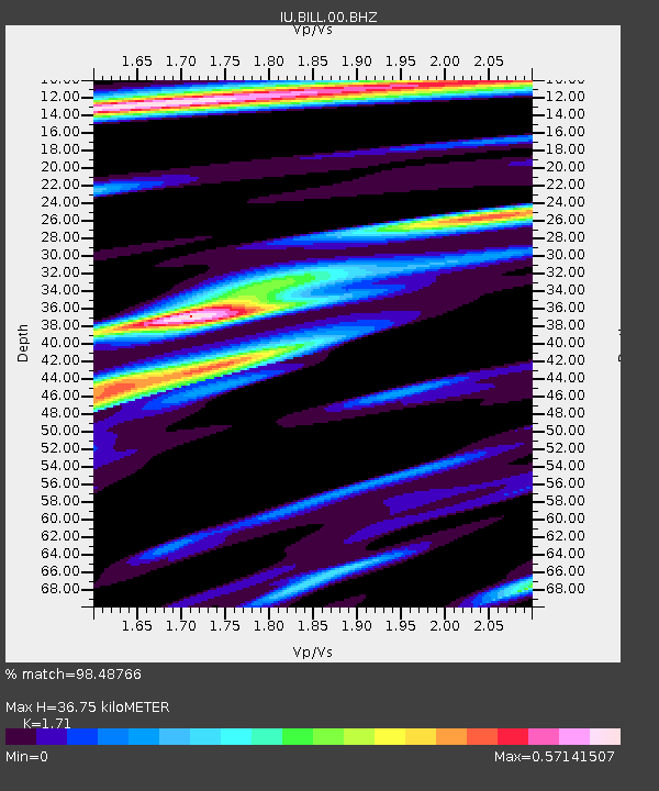
| Estimated Moho Depth: |
36.75 km |
| Estimated Crust Vp/Vs: |
1.71 |
| Assumed Crust Vp: |
6.577 km/s |
| Estimated Crust Vs: |
3.846 km/s |
| Estimated Crust Poisson's Ratio: |
0.24 |
|
| Radial Match: |
98.48766 % |
| Radial Bump: |
383 |
| Transverse Match: |
93.57663 % |
| Transverse Bump: |
400 |
| SOD ConfigId: |
626651 |
| Insert Time: |
2014-05-02 14:52:50.855 +0000 |
| GWidth: |
2.5 |
| Max Bumps: |
400 |
| Tol: |
0.001 |
|
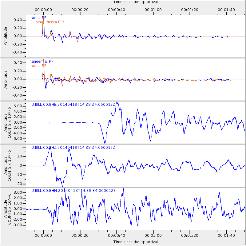
Signal To Noise
| Channel | StoN | STA | LTA |
| IU:BILL:00:BHZ:20140418T14:38:34.060012Z | 175.2006 | 1.1089302E-5 | 6.3294884E-8 |
| IU:BILL:00:BHN:20140418T14:38:34.060012Z | 11.108067 | 5.975935E-7 | 5.3798157E-8 |
| IU:BILL:00:BHE:20140418T14:38:34.060012Z | 72.42807 | 3.975434E-6 | 5.4888034E-8 |
| Arrivals |
| Ps | 4.1 SECOND |
| PpPs | 15 SECOND |
| PsPs/PpSs | 19 SECOND |


