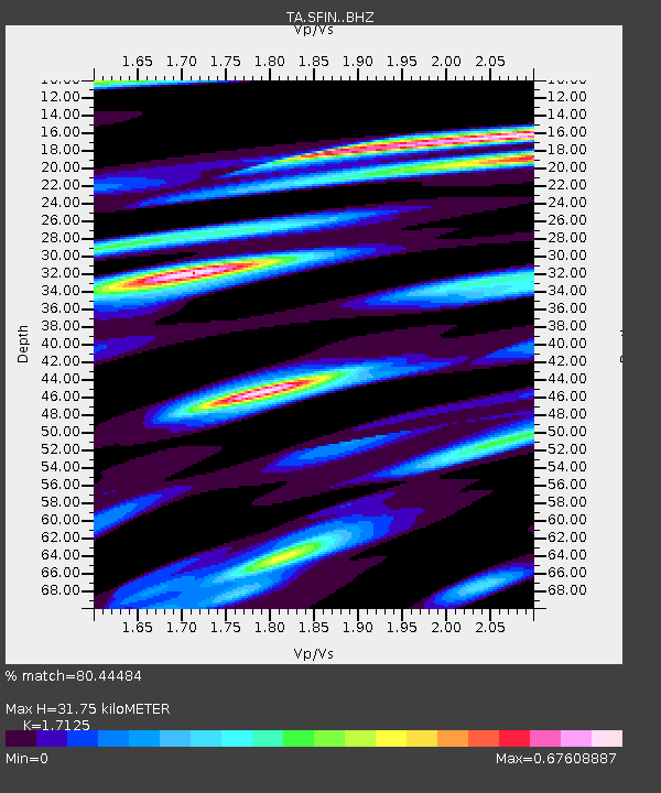
SFIN Lafayette, IN, USA - Earthquake Result Viewer

Earthquake location: Jujuy Province, Argentina
Earthquake latitude/longitude: -23.1/-66.7
Earthquake time(UTC): 2015/02/11 (042) 18:57:22 GMT
Earthquake Depth: 223 km
Earthquake Magnitude: 6.7 MWW, 6.7 MWC, 6.7 MWB, 6.9 MI
Earthquake Catalog/Contributor: NEIC PDE/NEIC COMCAT
Network: TA USArray Transportable Network (new EarthScope stations)
Station: SFIN Lafayette, IN, USA
Lat/Lon: 40.38 N/87.10 W
Elevation: 165 m
Distance: 66.0 deg
Az: 343.043 deg
Baz: 159.42 deg
Ray Param: 0.05725831
Estimated Moho Depth: 31.75 km
Estimated Crust Vp/Vs: 1.71
Assumed Crust Vp: 6.498 km/s
Estimated Crust Vs: 3.794 km/s
Estimated Crust Poisson's Ratio: 0.24
Radial Match: 80.44484 %
Radial Bump: 400
Transverse Match: 71.07506 %
Transverse Bump: 400
SOD ConfigId: 7019011
Insert Time: 2019-04-16 18:18:08.703 +0000
GWidth: 2.5
Max Bumps: 400
Tol: 0.001

Signal To Noise

ChannelStoNSTALTA
TA:SFIN: :BHZ:20150211T19:07:13.649993Z12.0417294.5641295E-63.790261E-7
TA:SFIN: :BHN:20150211T19:07:13.649993Z5.23898171.6150954E-63.082842E-7
TA:SFIN: :BHE:20150211T19:07:13.649993Z3.8627459.0534115E-72.3437767E-7
Arrivals
Ps3.6 SECOND
PpPs13 SECOND
PsPs/PpSs16 SECOND