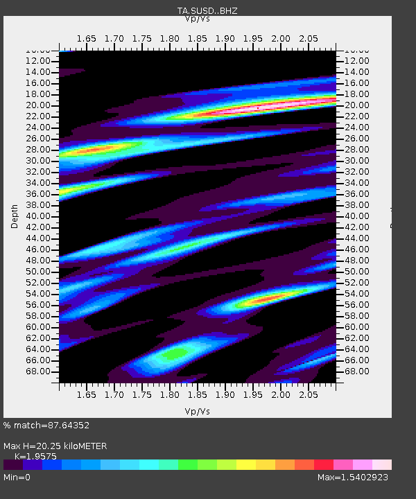
SUSD Miller, SD, USA - Earthquake Result Viewer

Earthquake location: Jujuy Province, Argentina
Earthquake latitude/longitude: -23.1/-66.7
Earthquake time(UTC): 2015/02/11 (042) 18:57:22 GMT
Earthquake Depth: 223 km
Earthquake Magnitude: 6.7 MWW, 6.7 MWC, 6.7 MWB, 6.9 MI
Earthquake Catalog/Contributor: NEIC PDE/NEIC COMCAT
Network: TA USArray Transportable Network (new EarthScope stations)
Station: SUSD Miller, SD, USA
Lat/Lon: 44.44 N/98.96 W
Elevation: 520 m
Distance: 73.4 deg
Az: 336.486 deg
Baz: 149.147 deg
Ray Param: 0.052406248
Estimated Moho Depth: 20.25 km
Estimated Crust Vp/Vs: 1.96
Assumed Crust Vp: 6.53 km/s
Estimated Crust Vs: 3.336 km/s
Estimated Crust Poisson's Ratio: 0.32
Radial Match: 87.64352 %
Radial Bump: 400
Transverse Match: 73.50435 %
Transverse Bump: 400
SOD ConfigId: 7019011
Insert Time: 2019-04-16 18:18:11.881 +0000
GWidth: 2.5
Max Bumps: 400
Tol: 0.001

Signal To Noise

ChannelStoNSTALTA
TA:SUSD: :BHZ:20150211T19:07:59.07498Z18.4322814.7530193E-62.5786386E-7
TA:SUSD: :BHN:20150211T19:07:59.07498Z7.458922.4255398E-63.2518645E-7
TA:SUSD: :BHE:20150211T19:07:59.07498Z3.4834251.1924948E-63.4233398E-7
Arrivals
Ps3.1 SECOND
PpPs8.9 SECOND
PsPs/PpSs12 SECOND