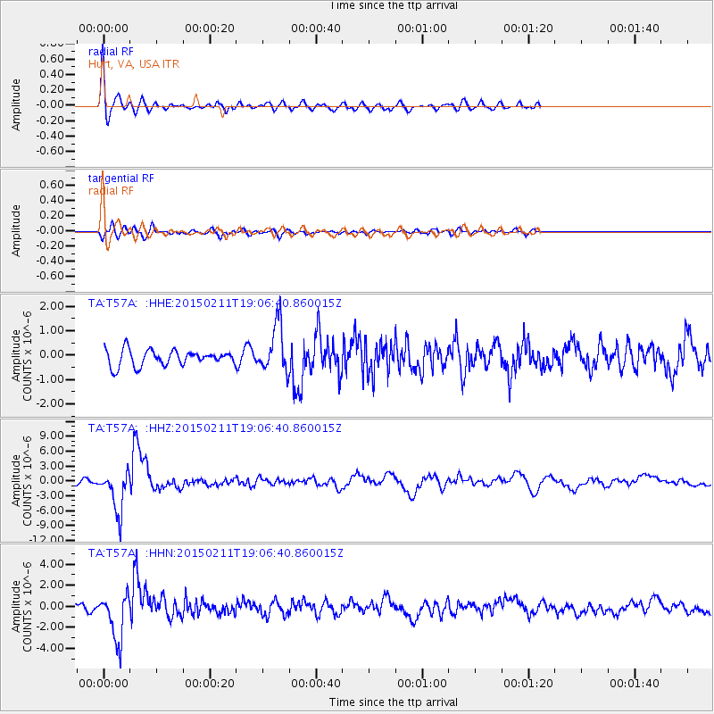
T57A Hurt, VA, USA - Earthquake Result Viewer
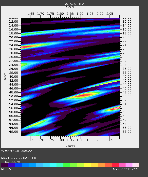
Earthquake location: Jujuy Province, Argentina
Earthquake latitude/longitude: -23.1/-66.7
Earthquake time(UTC): 2015/02/11 (042) 18:57:22 GMT
Earthquake Depth: 223 km
Earthquake Magnitude: 6.7 MWW, 6.7 MWC, 6.7 MWB, 6.9 MI
Earthquake Catalog/Contributor: NEIC PDE/NEIC COMCAT
Network: TA USArray Transportable Network (new EarthScope stations)
Station: T57A Hurt, VA, USA
Lat/Lon: 37.00 N/79.25 W
Elevation: 230 m
Distance: 60.9 deg
Az: 348.509 deg
Baz: 166.756 deg
Ray Param: 0.06049069
Estimated Moho Depth: 55.5 km
Estimated Crust Vp/Vs: 2.10
Assumed Crust Vp: 6.419 km/s
Estimated Crust Vs: 3.06 km/s
Estimated Crust Poisson's Ratio: 0.35
Radial Match: 81.40422 %
Radial Bump: 400
Transverse Match: 73.448784 %
Transverse Bump: 400
SOD ConfigId: 7019011
Insert Time: 2019-04-16 18:18:13.489 +0000
GWidth: 2.5
Max Bumps: 400
Tol: 0.001

Signal To Noise

ChannelStoNSTALTA
TA:T57A: :HHZ:20150211T19:06:40.860015Z5.62062034.2559013E-67.5719424E-7
TA:T57A: :HHN:20150211T19:06:40.860015Z5.986682.2272595E-63.7203583E-7
TA:T57A: :HHE:20150211T19:06:40.860015Z3.1392761.014934E-63.2330192E-7
Arrivals
Ps9.9 SECOND
PpPs26 SECOND
PsPs/PpSs36 SECOND