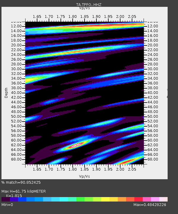
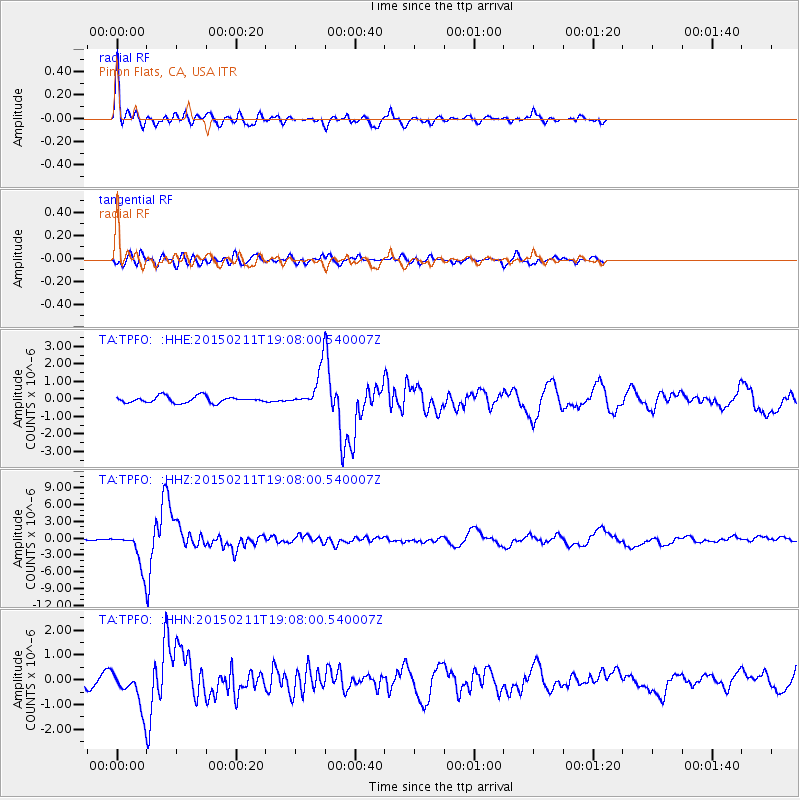
TPFO Pinon Flats, CA, USA - Earthquake Result Viewer

Earthquake location: Jujuy Province, Argentina
Earthquake latitude/longitude: -23.1/-66.7
Earthquake time(UTC): 2015/02/11 (042) 18:57:22 GMT
Earthquake Depth: 223 km
Earthquake Magnitude: 6.7 MWW, 6.7 MWC, 6.7 MWB, 6.9 MI
Earthquake Catalog/Contributor: NEIC PDE/NEIC COMCAT
Network: TA USArray Transportable Network (new EarthScope stations)
Station: TPFO Pinon Flats, CA, USA
Lat/Lon: 33.61 N/116.45 W
Elevation: 1275 m
Distance: 73.7 deg
Az: 318.4 deg
Baz: 132.907 deg
Ray Param: 0.052247655
Estimated Moho Depth: 61.75 km
Estimated Crust Vp/Vs: 1.82
Assumed Crust Vp: 6.264 km/s
Estimated Crust Vs: 3.451 km/s
Estimated Crust Poisson's Ratio: 0.28
Radial Match: 90.852425 %
Radial Bump: 400
Transverse Match: 77.703354 %
Transverse Bump: 400
SOD ConfigId: 7019011
Insert Time: 2019-04-16 18:18:18.075 +0000
GWidth: 2.5
Max Bumps: 400
Tol: 0.001

Signal To Noise

ChannelStoNSTALTA
TA:TPFO: :HHZ:20150211T19:08:00.540007Z12.2700243.0937385E-62.521379E-7
TA:TPFO: :HHN:20150211T19:08:00.540007Z4.497347.445102E-71.6554456E-7
TA:TPFO: :HHE:20150211T19:08:00.540007Z5.2343019.401536E-71.7961396E-7
Arrivals
Ps8.3 SECOND
PpPs27 SECOND
PsPs/PpSs35 SECOND