You are here: Home > Network List > TA - USArray Transportable Network (new EarthScope stations) Stations List
> Station V56A Mocksville, NC, USA > Earthquake Result Viewer
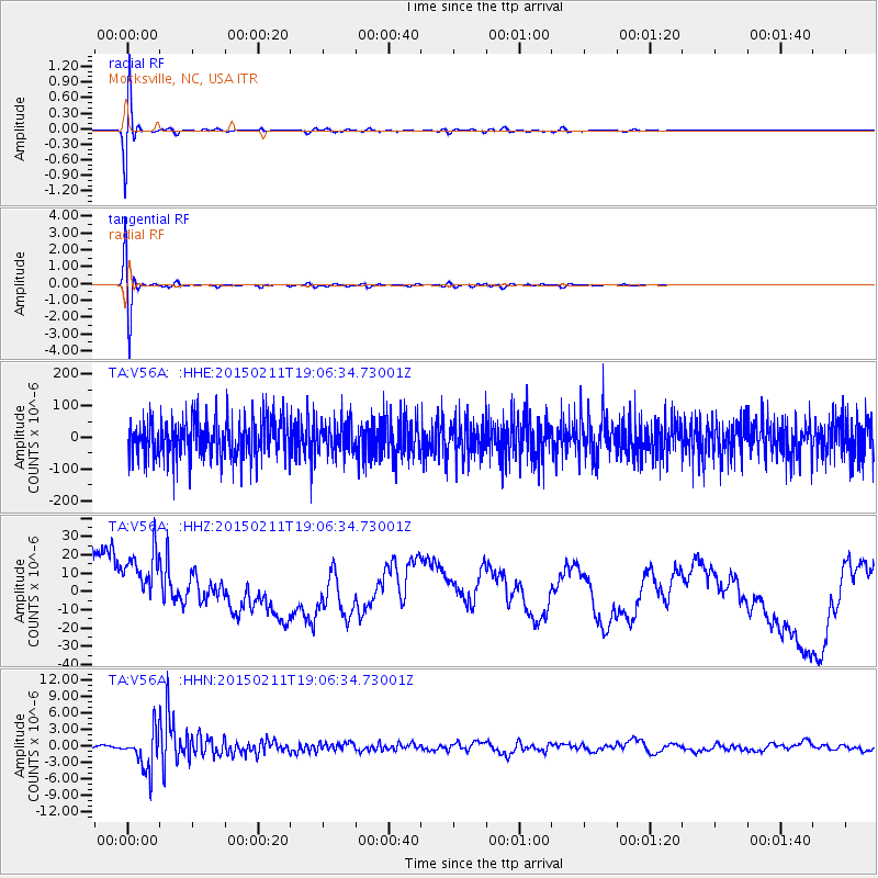
V56A Mocksville, NC, USA - Earthquake Result Viewer
*The percent match for this event was below the threshold and hence no stack was calculated.
| Earthquake location: |
Jujuy Province, Argentina |
| Earthquake latitude/longitude: |
-23.1/-66.7 |
| Earthquake time(UTC): |
2015/02/11 (042) 18:57:22 GMT |
| Earthquake Depth: |
223 km |
| Earthquake Magnitude: |
6.7 MWW, 6.7 MWC, 6.7 MWB, 6.9 MI |
| Earthquake Catalog/Contributor: |
NEIC PDE/NEIC COMCAT |
|
| Network: |
TA USArray Transportable Network (new EarthScope stations) |
| Station: |
V56A Mocksville, NC, USA |
| Lat/Lon: |
35.81 N/80.50 W |
| Elevation: |
237 m |
|
| Distance: |
60.0 deg |
| Az: |
347.063 deg |
| Baz: |
165.309 deg |
| Ray Param: |
$rayparam |
*The percent match for this event was below the threshold and hence was not used in the summary stack. |
|
| Radial Match: |
75.606636 % |
| Radial Bump: |
400 |
| Transverse Match: |
77.17396 % |
| Transverse Bump: |
400 |
| SOD ConfigId: |
7019011 |
| Insert Time: |
2019-04-16 18:18:24.784 +0000 |
| GWidth: |
2.5 |
| Max Bumps: |
400 |
| Tol: |
0.001 |
|
Signal To Noise
| Channel | StoN | STA | LTA |
| TA:V56A: :HHZ:20150211T19:06:34.73001Z | 1.7596039 | 2.5405292E-5 | 1.4438076E-5 |
| TA:V56A: :HHN:20150211T19:06:34.73001Z | 8.578687 | 3.5830042E-6 | 4.1766347E-7 |
| TA:V56A: :HHE:20150211T19:06:34.73001Z | 0.77874905 | 4.824214E-5 | 6.1948245E-5 |
| Arrivals |
| Ps | |
| PpPs | |
| PsPs/PpSs | |


