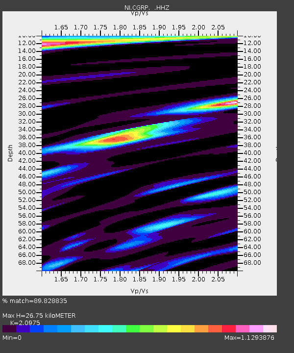
CGRP Cima Grappa - Earthquake Result Viewer
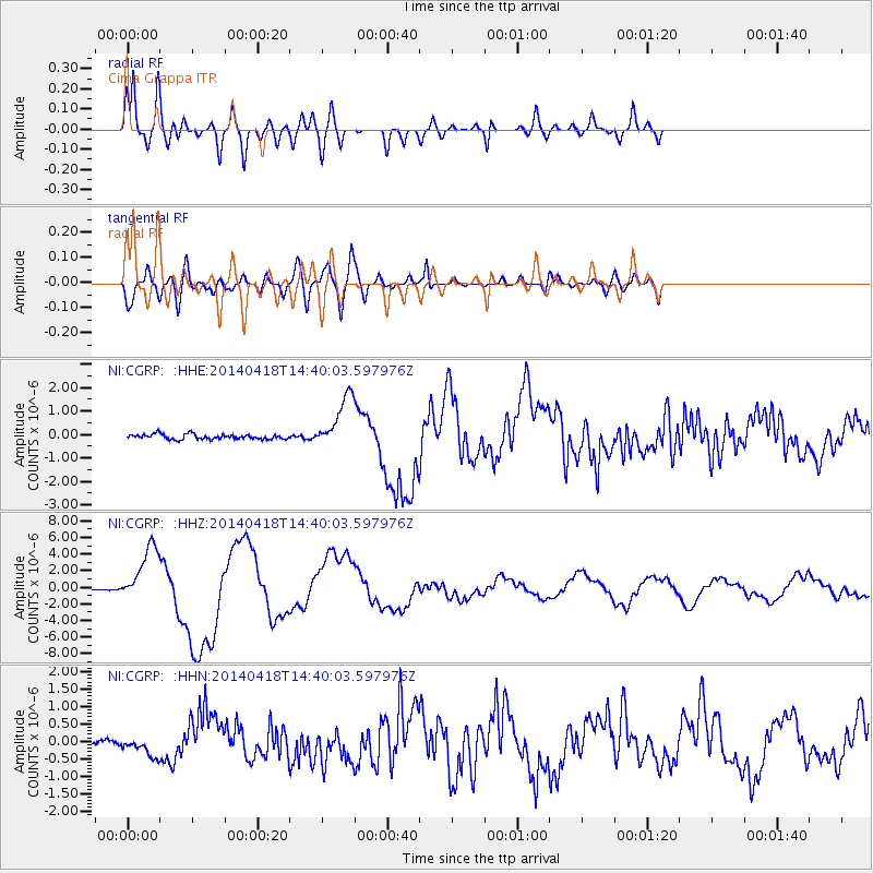
Earthquake location: Guerrero, Mexico
Earthquake latitude/longitude: 17.6/-100.8
Earthquake time(UTC): 2014/04/18 (108) 14:27:26 GMT
Earthquake Depth: 24 km
Earthquake Magnitude: 7.2 MWW, 7.0 MWB, 7.3 MWC, 7.5 MI
Earthquake Catalog/Contributor: NEIC PDE/NEIC COMCAT
Network: NI North-East Italy Broadband Network
Station: CGRP Cima Grappa
Lat/Lon: 45.88 N/11.80 E
Elevation: 1757 m
Distance: 92.4 deg
Az: 40.195 deg
Baz: 298.188 deg
Ray Param: 0.04145914
Estimated Moho Depth: 26.75 km
Estimated Crust Vp/Vs: 2.10
Assumed Crust Vp: 6.155 km/s
Estimated Crust Vs: 2.934 km/s
Estimated Crust Poisson's Ratio: 0.35
Radial Match: 89.828835 %
Radial Bump: 400
Transverse Match: 74.7877 %
Transverse Bump: 400
SOD ConfigId: 626651
Insert Time: 2014-05-02 14:57:43.470 +0000
GWidth: 2.5
Max Bumps: 400
Tol: 0.001

Signal To Noise

ChannelStoNSTALTA
NI:CGRP: :HHZ:20140418T14:40:03.597976Z54.6606753.4748957E-66.357213E-8
NI:CGRP: :HHN:20140418T14:40:03.597976Z2.948282.534426E-78.596287E-8
NI:CGRP: :HHE:20140418T14:40:03.597976Z10.6444841.1369575E-61.068119E-7
Arrivals
Ps4.8 SECOND
PpPs13 SECOND
PsPs/PpSs18 SECOND