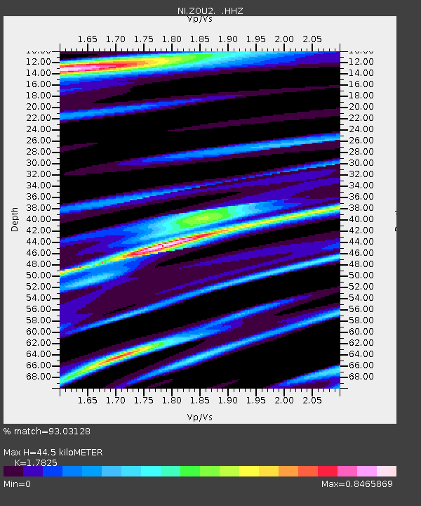
ZOU2 Zouf Plan - Earthquake Result Viewer

Earthquake location: Guerrero, Mexico
Earthquake latitude/longitude: 17.6/-100.8
Earthquake time(UTC): 2014/04/18 (108) 14:27:26 GMT
Earthquake Depth: 24 km
Earthquake Magnitude: 7.2 MWW, 7.0 MWB, 7.3 MWC, 7.5 MI
Earthquake Catalog/Contributor: NEIC PDE/NEIC COMCAT
Network: NI North-East Italy Broadband Network
Station: ZOU2 Zouf Plan
Lat/Lon: 46.56 N/12.97 E
Elevation: 1896 m
Distance: 92.8 deg
Az: 39.211 deg
Baz: 299.074 deg
Ray Param: 0.041383028
Estimated Moho Depth: 44.5 km
Estimated Crust Vp/Vs: 1.78
Assumed Crust Vp: 6.35 km/s
Estimated Crust Vs: 3.562 km/s
Estimated Crust Poisson's Ratio: 0.27
Radial Match: 93.03128 %
Radial Bump: 400
Transverse Match: 81.6291 %
Transverse Bump: 400
SOD ConfigId: 626651
Insert Time: 2014-05-02 14:58:10.167 +0000
GWidth: 2.5
Max Bumps: 400
Tol: 0.001

Signal To Noise

ChannelStoNSTALTA
NI:ZOU2: :HHZ:20140418T14:40:05.388015Z25.527263.223868E-61.2629118E-7
NI:ZOU2: :HHN:20140418T14:40:05.388015Z2.07450183.0569063E-71.4735618E-7
NI:ZOU2: :HHE:20140418T14:40:05.388015Z9.5688411.046766E-61.09393184E-7
Arrivals
Ps5.6 SECOND
PpPs19 SECOND
PsPs/PpSs25 SECOND