You are here: Home > Network List > UW - Pacific Northwest Regional Seismic Network Stations List
> Station KENT Carlson Farm, Grass Valley, OR, USA > Earthquake Result Viewer
KENT Carlson Farm, Grass Valley, OR, USA - Earthquake Result Viewer
| Earthquake location: |
Jujuy Province, Argentina |
| Earthquake latitude/longitude: |
-23.1/-66.7 |
| Earthquake time(UTC): |
2015/02/11 (042) 18:57:22 GMT |
| Earthquake Depth: |
223 km |
| Earthquake Magnitude: |
6.7 MWW, 6.7 MWC, 6.7 MWB, 6.9 MI |
| Earthquake Catalog/Contributor: |
NEIC PDE/NEIC COMCAT |
|
| Network: |
UW Pacific Northwest Regional Seismic Network |
| Station: |
KENT Carlson Farm, Grass Valley, OR, USA |
| Lat/Lon: |
45.24 N/120.64 W |
| Elevation: |
780 m |
|
| Distance: |
83.9 deg |
| Az: |
324.935 deg |
| Baz: |
131.528 deg |
| Ray Param: |
0.04533917 |
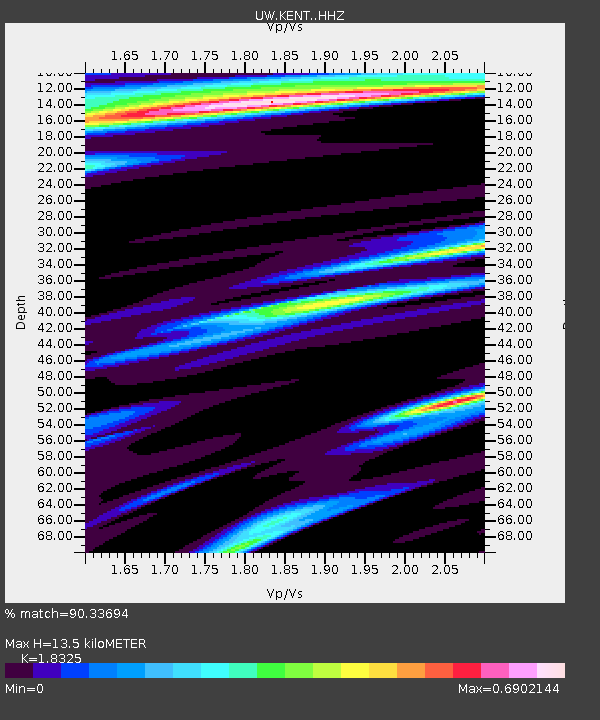
| Estimated Moho Depth: |
13.5 km |
| Estimated Crust Vp/Vs: |
1.83 |
| Assumed Crust Vp: |
6.597 km/s |
| Estimated Crust Vs: |
3.6 km/s |
| Estimated Crust Poisson's Ratio: |
0.29 |
|
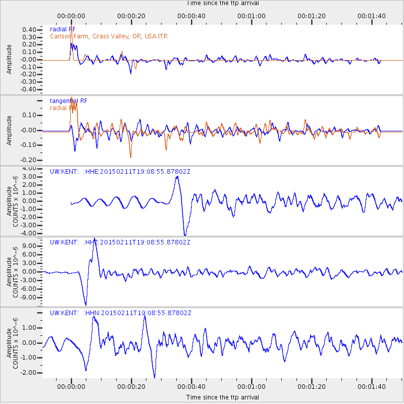
| Radial Match: |
90.33694 % |
| Radial Bump: |
400 |
| Transverse Match: |
73.6901 % |
| Transverse Bump: |
400 |
| SOD ConfigId: |
7019011 |
| Insert Time: |
2019-04-16 18:19:45.326 +0000 |
| GWidth: |
2.5 |
| Max Bumps: |
400 |
| Tol: |
0.001 |
|
Signal To Noise
| Channel | StoN | STA | LTA |
| UW:KENT: :HHZ:20150211T19:08:55.87802Z | 20.26581 | 4.337578E-6 | 2.1403429E-7 |
| UW:KENT: :HHN:20150211T19:08:55.87802Z | 2.0047007 | 6.7752893E-7 | 3.379701E-7 |
| UW:KENT: :HHE:20150211T19:08:55.87802Z | 2.0234203 | 8.4150776E-7 | 4.1588382E-7 |
| Arrivals |
| Ps | 1.7 SECOND |
| PpPs | 5.7 SECOND |
| PsPs/PpSs | 7.4 SECOND |


