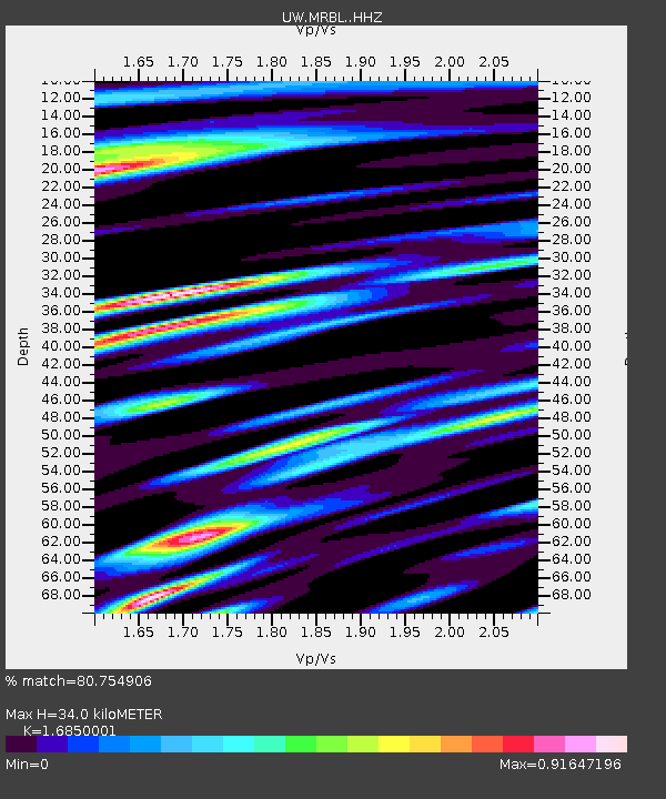
MRBL Marblemount, WA, USA - Earthquake Result Viewer
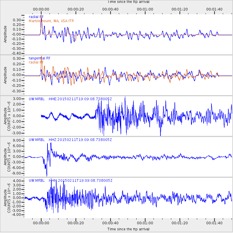
Earthquake location: Jujuy Province, Argentina
Earthquake latitude/longitude: -23.1/-66.7
Earthquake time(UTC): 2015/02/11 (042) 18:57:22 GMT
Earthquake Depth: 223 km
Earthquake Magnitude: 6.7 MWW, 6.7 MWC, 6.7 MWB, 6.9 MI
Earthquake Catalog/Contributor: NEIC PDE/NEIC COMCAT
Network: UW Pacific Northwest Regional Seismic Network
Station: MRBL Marblemount, WA, USA
Lat/Lon: 48.52 N/121.48 W
Elevation: 75 m
Distance: 86.5 deg
Az: 327.024 deg
Baz: 131.086 deg
Ray Param: 0.04348879
Estimated Moho Depth: 34.0 km
Estimated Crust Vp/Vs: 1.69
Assumed Crust Vp: 6.566 km/s
Estimated Crust Vs: 3.897 km/s
Estimated Crust Poisson's Ratio: 0.23
Radial Match: 80.754906 %
Radial Bump: 400
Transverse Match: 79.89322 %
Transverse Bump: 400
SOD ConfigId: 7019011
Insert Time: 2019-04-16 18:19:49.680 +0000
GWidth: 2.5
Max Bumps: 400
Tol: 0.001

Signal To Noise

ChannelStoNSTALTA
UW:MRBL: :HHZ:20150211T19:09:08.738005Z11.4301423.5726841E-63.125669E-7
UW:MRBL: :HHN:20150211T19:09:08.738005Z4.23739771.021662E-62.41106E-7
UW:MRBL: :HHE:20150211T19:09:08.738005Z3.4717371.0632525E-63.0625952E-7
Arrivals
Ps3.6 SECOND
PpPs14 SECOND
PsPs/PpSs17 SECOND