You are here: Home > Network List > PO - Portable Observatories for Lithospheric Analysis and Research Investigating Seis Stations List
> Station LATQ La Tuque, Quebec, QC > Earthquake Result Viewer
LATQ La Tuque, Quebec, QC - Earthquake Result Viewer
| Earthquake location: |
Guerrero, Mexico |
| Earthquake latitude/longitude: |
17.6/-100.8 |
| Earthquake time(UTC): |
2014/04/18 (108) 14:27:26 GMT |
| Earthquake Depth: |
24 km |
| Earthquake Magnitude: |
7.2 MWW, 7.0 MWB, 7.3 MWC, 7.5 MI |
| Earthquake Catalog/Contributor: |
NEIC PDE/NEIC COMCAT |
|
| Network: |
PO Portable Observatories for Lithospheric Analysis and Research Investigating Seis |
| Station: |
LATQ La Tuque, Quebec, QC |
| Lat/Lon: |
47.38 N/72.78 W |
| Elevation: |
163 m |
|
| Distance: |
37.6 deg |
| Az: |
31.553 deg |
| Baz: |
227.277 deg |
| Ray Param: |
0.07600113 |
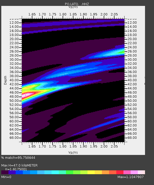
| Estimated Moho Depth: |
47.0 km |
| Estimated Crust Vp/Vs: |
1.62 |
| Assumed Crust Vp: |
6.61 km/s |
| Estimated Crust Vs: |
4.087 km/s |
| Estimated Crust Poisson's Ratio: |
0.19 |
|
| Radial Match: |
95.758644 % |
| Radial Bump: |
187 |
| Transverse Match: |
57.037643 % |
| Transverse Bump: |
400 |
| SOD ConfigId: |
626651 |
| Insert Time: |
2014-05-02 14:59:29.110 +0000 |
| GWidth: |
2.5 |
| Max Bumps: |
400 |
| Tol: |
0.001 |
|

Signal To Noise
| Channel | StoN | STA | LTA |
| PO:LATQ: :HHZ:20140418T14:34:08.689987Z | 46.74833 | 4.4196404E-6 | 9.4541136E-8 |
| PO:LATQ: :HHN:20140418T14:34:08.689987Z | 23.62715 | 1.969374E-6 | 8.3352155E-8 |
| PO:LATQ: :HHE:20140418T14:34:08.689987Z | 28.64032 | 2.1588075E-6 | 7.537651E-8 |
| Arrivals |
| Ps | 4.8 SECOND |
| PpPs | 17 SECOND |
| PsPs/PpSs | 22 SECOND |


