You are here: Home > Network List > PO - Portable Observatories for Lithospheric Analysis and Research Investigating Seis Stations List
> Station MATQ Matagami, QC > Earthquake Result Viewer
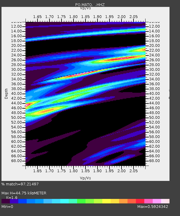
MATQ Matagami, QC - Earthquake Result Viewer
| Earthquake location: |
Guerrero, Mexico |
| Earthquake latitude/longitude: |
17.6/-100.8 |
| Earthquake time(UTC): |
2014/04/18 (108) 14:27:26 GMT |
| Earthquake Depth: |
24 km |
| Earthquake Magnitude: |
7.2 MWW, 7.0 MWB, 7.3 MWC, 7.5 MI |
| Earthquake Catalog/Contributor: |
NEIC PDE/NEIC COMCAT |
|
| Network: |
PO Portable Observatories for Lithospheric Analysis and Research Investigating Seis |
| Station: |
MATQ Matagami, QC |
| Lat/Lon: |
49.76 N/77.64 W |
| Elevation: |
280 m |
|
| Distance: |
37.2 deg |
| Az: |
24.996 deg |
| Baz: |
218.434 deg |
| Ray Param: |
0.07625049 |
| Estimated Moho Depth: |
44.75 km |
| Estimated Crust Vp/Vs: |
1.60 |
| Assumed Crust Vp: |
6.61 km/s |
| Estimated Crust Vs: |
4.131 km/s |
| Estimated Crust Poisson's Ratio: |
0.18 |
|
| Radial Match: |
97.21497 % |
| Radial Bump: |
127 |
| Transverse Match: |
93.199104 % |
| Transverse Bump: |
299 |
| SOD ConfigId: |
626651 |
| Insert Time: |
2014-05-02 14:59:30.377 +0000 |
| GWidth: |
2.5 |
| Max Bumps: |
400 |
| Tol: |
0.001 |
|

Signal To Noise
| Channel | StoN | STA | LTA |
| PO:MATQ: :HHZ:20140418T14:34:04.87001Z | 69.40055 | 4.1781764E-6 | 6.0203796E-8 |
| PO:MATQ: :HHN:20140418T14:34:04.87001Z | 43.658005 | 2.5134752E-6 | 5.7571928E-8 |
| PO:MATQ: :HHE:20140418T14:34:04.87001Z | 21.260529 | 1.1628869E-6 | 5.4696986E-8 |
| Arrivals |
| Ps | 4.4 SECOND |
| PpPs | 16 SECOND |
| PsPs/PpSs | 21 SECOND |


