You are here: Home > Network List > TA - USArray Transportable Network (new EarthScope stations) Stations List
> Station D58A Chemin du LacGrosbois, Trois-Rives, QC, CAN > Earthquake Result Viewer
D58A Chemin du LacGrosbois, Trois-Rives, QC, CAN - Earthquake Result Viewer
| Earthquake location: |
Guerrero, Mexico |
| Earthquake latitude/longitude: |
17.6/-100.8 |
| Earthquake time(UTC): |
2014/04/18 (108) 14:27:26 GMT |
| Earthquake Depth: |
24 km |
| Earthquake Magnitude: |
7.2 MWW, 7.0 MWB, 7.3 MWC, 7.5 MI |
| Earthquake Catalog/Contributor: |
NEIC PDE/NEIC COMCAT |
|
| Network: |
TA USArray Transportable Network (new EarthScope stations) |
| Station: |
D58A Chemin du LacGrosbois, Trois-Rives, QC, CAN |
| Lat/Lon: |
47.10 N/72.88 W |
| Elevation: |
398 m |
|
| Distance: |
37.4 deg |
| Az: |
31.824 deg |
| Baz: |
227.419 deg |
| Ray Param: |
0.07613792 |
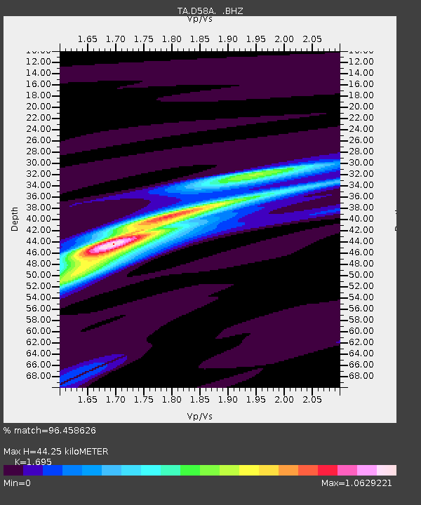
| Estimated Moho Depth: |
44.25 km |
| Estimated Crust Vp/Vs: |
1.70 |
| Assumed Crust Vp: |
6.61 km/s |
| Estimated Crust Vs: |
3.9 km/s |
| Estimated Crust Poisson's Ratio: |
0.23 |
|
| Radial Match: |
96.458626 % |
| Radial Bump: |
145 |
| Transverse Match: |
50.51452 % |
| Transverse Bump: |
400 |
| SOD ConfigId: |
626651 |
| Insert Time: |
2014-05-02 15:02:13.822 +0000 |
| GWidth: |
2.5 |
| Max Bumps: |
400 |
| Tol: |
0.001 |
|
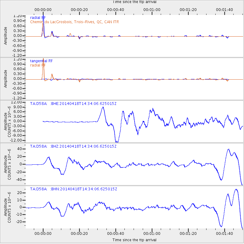
Signal To Noise
| Channel | StoN | STA | LTA |
| TA:D58A: :BHZ:20140418T14:34:06.625015Z | 53.77353 | 1.07653705E-5 | 2.0019831E-7 |
| TA:D58A: :BHN:20140418T14:34:06.625015Z | 24.56189 | 4.367994E-6 | 1.7783623E-7 |
| TA:D58A: :BHE:20140418T14:34:06.625015Z | 34.015877 | 5.182546E-6 | 1.5235668E-7 |
| Arrivals |
| Ps | 5.1 SECOND |
| PpPs | 17 SECOND |
| PsPs/PpSs | 22 SECOND |


