You are here: Home > Network List > TA - USArray Transportable Network (new EarthScope stations) Stations List
> Station E51A G1948 Merrick Township, ON, CAN > Earthquake Result Viewer
E51A G1948 Merrick Township, ON, CAN - Earthquake Result Viewer
| Earthquake location: |
Guerrero, Mexico |
| Earthquake latitude/longitude: |
17.6/-100.8 |
| Earthquake time(UTC): |
2014/04/18 (108) 14:27:26 GMT |
| Earthquake Depth: |
24 km |
| Earthquake Magnitude: |
7.2 MWW, 7.0 MWB, 7.3 MWC, 7.5 MI |
| Earthquake Catalog/Contributor: |
NEIC PDE/NEIC COMCAT |
|
| Network: |
TA USArray Transportable Network (new EarthScope stations) |
| Station: |
E51A G1948 Merrick Township, ON, CAN |
| Lat/Lon: |
46.53 N/79.49 W |
| Elevation: |
369 m |
|
| Distance: |
33.9 deg |
| Az: |
26.778 deg |
| Baz: |
218.507 deg |
| Ray Param: |
0.0779813 |
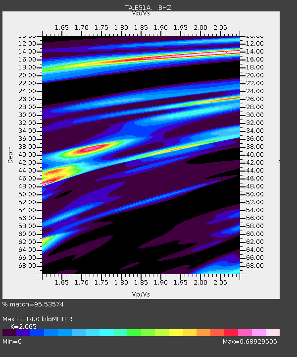
| Estimated Moho Depth: |
14.0 km |
| Estimated Crust Vp/Vs: |
2.07 |
| Assumed Crust Vp: |
6.622 km/s |
| Estimated Crust Vs: |
3.207 km/s |
| Estimated Crust Poisson's Ratio: |
0.35 |
|
| Radial Match: |
95.53574 % |
| Radial Bump: |
228 |
| Transverse Match: |
73.43061 % |
| Transverse Bump: |
400 |
| SOD ConfigId: |
626651 |
| Insert Time: |
2014-05-02 15:02:47.617 +0000 |
| GWidth: |
2.5 |
| Max Bumps: |
400 |
| Tol: |
0.001 |
|
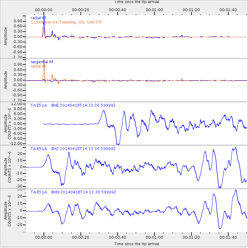
Signal To Noise
| Channel | StoN | STA | LTA |
| TA:E51A: :BHZ:20140418T14:33:36.59999Z | 74.05157 | 1.09438515E-5 | 1.4778689E-7 |
| TA:E51A: :BHN:20140418T14:33:36.59999Z | 46.567764 | 5.934331E-6 | 1.2743432E-7 |
| TA:E51A: :BHE:20140418T14:33:36.59999Z | 33.08503 | 4.7439253E-6 | 1.4338585E-7 |
| Arrivals |
| Ps | 2.4 SECOND |
| PpPs | 6.0 SECOND |
| PsPs/PpSs | 8.5 SECOND |


