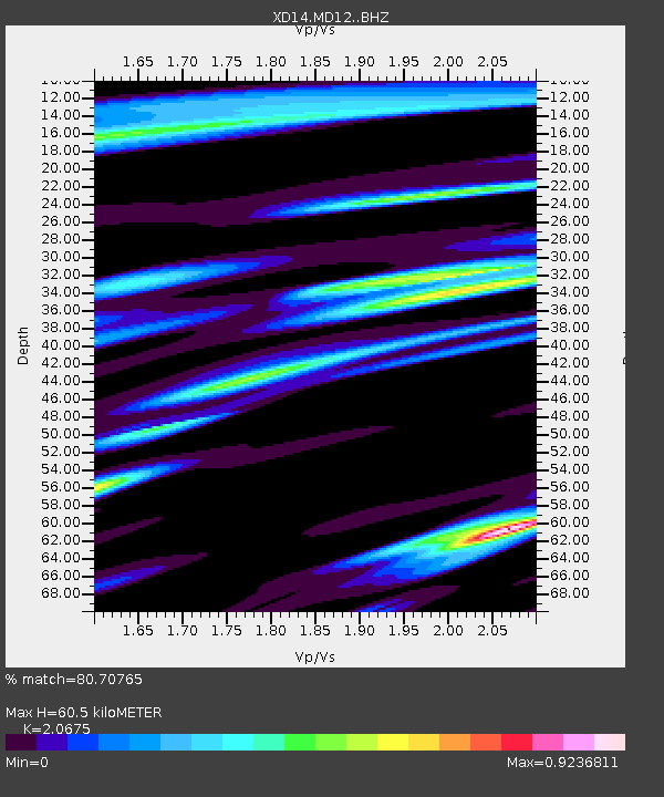
MD12 "Mount St Helens, WA" - Earthquake Result Viewer

Earthquake location: Jujuy Province, Argentina
Earthquake latitude/longitude: -23.1/-66.7
Earthquake time(UTC): 2015/02/11 (042) 18:57:22 GMT
Earthquake Depth: 223 km
Earthquake Magnitude: 6.7 MWW, 6.7 MWC, 6.7 MWB, 6.9 MI
Earthquake Catalog/Contributor: NEIC PDE/NEIC COMCAT
Network: XD Illuminating the architecture of the greater Mount St. Helens magmatic systems f
Station: MD12 "Mount St Helens, WA"
Lat/Lon: 46.48 N/121.22 W
Elevation: 1496 m
Distance: 85.0 deg
Az: 325.6 deg
Baz: 131.174 deg
Ray Param: 0.044540517
Estimated Moho Depth: 60.5 km
Estimated Crust Vp/Vs: 2.07
Assumed Crust Vp: 6.597 km/s
Estimated Crust Vs: 3.191 km/s
Estimated Crust Poisson's Ratio: 0.35
Radial Match: 80.70765 %
Radial Bump: 361
Transverse Match: 67.33948 %
Transverse Bump: 400
SOD ConfigId: 7019011
Insert Time: 2019-04-16 18:20:51.589 +0000
GWidth: 2.5
Max Bumps: 400
Tol: 0.001

Signal To Noise

ChannelStoNSTALTA
XD:MD12: :BHZ:20150211T19:09:01.524993Z16.563463.3898223E-62.0465666E-7
XD:MD12: :BHN:20150211T19:09:01.524993Z3.17797118.940422E-72.8132484E-7
XD:MD12: :BHE:20150211T19:09:01.524993Z4.0049559.292237E-72.3201852E-7
Arrivals
Ps10 SECOND
PpPs28 SECOND
PsPs/PpSs38 SECOND