You are here: Home > Network List > TA - USArray Transportable Network (new EarthScope stations) Stations List
> Station F52A Sundridge, ON, CAN > Earthquake Result Viewer
F52A Sundridge, ON, CAN - Earthquake Result Viewer
| Earthquake location: |
Guerrero, Mexico |
| Earthquake latitude/longitude: |
17.6/-100.8 |
| Earthquake time(UTC): |
2014/04/18 (108) 14:27:26 GMT |
| Earthquake Depth: |
24 km |
| Earthquake Magnitude: |
7.2 MWW, 7.0 MWB, 7.3 MWC, 7.5 MI |
| Earthquake Catalog/Contributor: |
NEIC PDE/NEIC COMCAT |
|
| Network: |
TA USArray Transportable Network (new EarthScope stations) |
| Station: |
F52A Sundridge, ON, CAN |
| Lat/Lon: |
45.80 N/79.32 W |
| Elevation: |
351 m |
|
| Distance: |
33.4 deg |
| Az: |
27.783 deg |
| Baz: |
219.466 deg |
| Ray Param: |
0.0782113 |
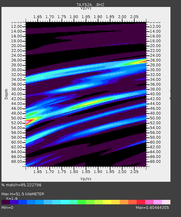
| Estimated Moho Depth: |
51.5 km |
| Estimated Crust Vp/Vs: |
1.60 |
| Assumed Crust Vp: |
6.577 km/s |
| Estimated Crust Vs: |
4.111 km/s |
| Estimated Crust Poisson's Ratio: |
0.18 |
|
| Radial Match: |
95.222786 % |
| Radial Bump: |
252 |
| Transverse Match: |
78.75381 % |
| Transverse Bump: |
400 |
| SOD ConfigId: |
626651 |
| Insert Time: |
2014-05-02 15:03:54.961 +0000 |
| GWidth: |
2.5 |
| Max Bumps: |
400 |
| Tol: |
0.001 |
|
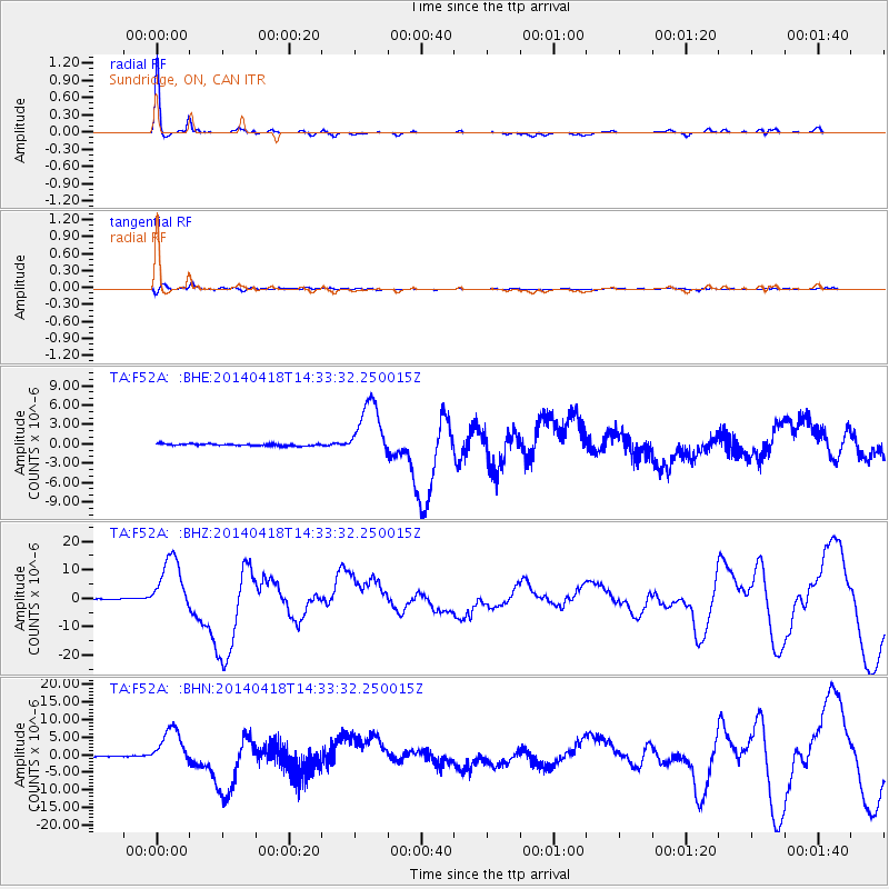
Signal To Noise
| Channel | StoN | STA | LTA |
| TA:F52A: :BHZ:20140418T14:33:32.250015Z | 59.316322 | 1.0049465E-5 | 1.6942158E-7 |
| TA:F52A: :BHN:20140418T14:33:32.250015Z | 34.764713 | 5.349365E-6 | 1.5387342E-7 |
| TA:F52A: :BHE:20140418T14:33:32.250015Z | 29.271366 | 4.476935E-6 | 1.5294589E-7 |
| Arrivals |
| Ps | 5.1 SECOND |
| PpPs | 19 SECOND |
| PsPs/PpSs | 24 SECOND |


