You are here: Home > Network List > TA - USArray Transportable Network (new EarthScope stations) Stations List
> Station F57A Harrington, QC, CAN > Earthquake Result Viewer
F57A Harrington, QC, CAN - Earthquake Result Viewer
| Earthquake location: |
Guerrero, Mexico |
| Earthquake latitude/longitude: |
17.6/-100.8 |
| Earthquake time(UTC): |
2014/04/18 (108) 14:27:26 GMT |
| Earthquake Depth: |
24 km |
| Earthquake Magnitude: |
7.2 MWW, 7.0 MWB, 7.3 MWC, 7.5 MI |
| Earthquake Catalog/Contributor: |
NEIC PDE/NEIC COMCAT |
|
| Network: |
TA USArray Transportable Network (new EarthScope stations) |
| Station: |
F57A Harrington, QC, CAN |
| Lat/Lon: |
45.81 N/74.69 W |
| Elevation: |
178 m |
|
| Distance: |
35.6 deg |
| Az: |
31.958 deg |
| Baz: |
226.218 deg |
| Ray Param: |
0.07711222 |
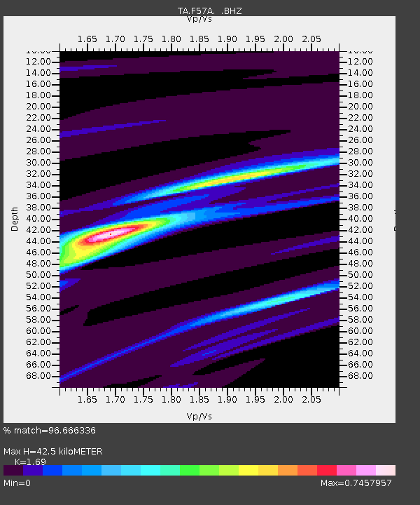
| Estimated Moho Depth: |
42.5 km |
| Estimated Crust Vp/Vs: |
1.69 |
| Assumed Crust Vp: |
6.419 km/s |
| Estimated Crust Vs: |
3.798 km/s |
| Estimated Crust Poisson's Ratio: |
0.23 |
|
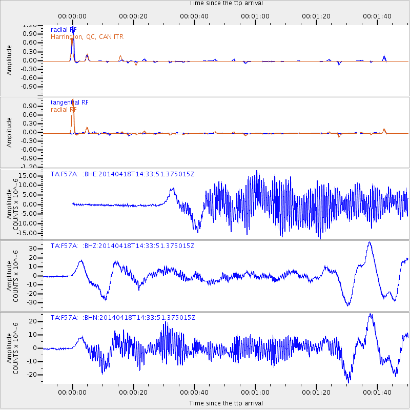
| Radial Match: |
96.666336 % |
| Radial Bump: |
150 |
| Transverse Match: |
55.389587 % |
| Transverse Bump: |
400 |
| SOD ConfigId: |
626651 |
| Insert Time: |
2014-05-02 15:04:00.807 +0000 |
| GWidth: |
2.5 |
| Max Bumps: |
400 |
| Tol: |
0.001 |
|
Signal To Noise
| Channel | StoN | STA | LTA |
| TA:F57A: :BHZ:20140418T14:33:51.375015Z | 53.386242 | 1.0385487E-5 | 1.9453489E-7 |
| TA:F57A: :BHN:20140418T14:33:51.375015Z | 18.504469 | 4.939892E-6 | 2.669567E-7 |
| TA:F57A: :BHE:20140418T14:33:51.375015Z | 16.540531 | 4.9162695E-6 | 2.9722563E-7 |
| Arrivals |
| Ps | 4.9 SECOND |
| PpPs | 16 SECOND |
| PsPs/PpSs | 21 SECOND |


