You are here: Home > Network List > TA - USArray Transportable Network (new EarthScope stations) Stations List
> Station F58A St-Lin Laurentide, QC, CAN > Earthquake Result Viewer
F58A St-Lin Laurentide, QC, CAN - Earthquake Result Viewer
| Earthquake location: |
Guerrero, Mexico |
| Earthquake latitude/longitude: |
17.6/-100.8 |
| Earthquake time(UTC): |
2014/04/18 (108) 14:27:26 GMT |
| Earthquake Depth: |
24 km |
| Earthquake Magnitude: |
7.2 MWW, 7.0 MWB, 7.3 MWC, 7.5 MI |
| Earthquake Catalog/Contributor: |
NEIC PDE/NEIC COMCAT |
|
| Network: |
TA USArray Transportable Network (new EarthScope stations) |
| Station: |
F58A St-Lin Laurentide, QC, CAN |
| Lat/Lon: |
45.87 N/73.81 W |
| Elevation: |
73 m |
|
| Distance: |
36.1 deg |
| Az: |
32.609 deg |
| Baz: |
227.374 deg |
| Ray Param: |
0.076849096 |
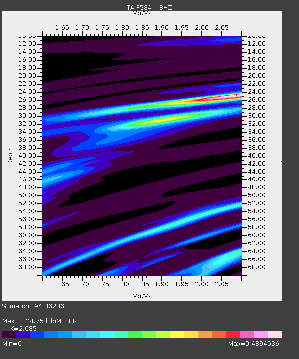
| Estimated Moho Depth: |
24.75 km |
| Estimated Crust Vp/Vs: |
2.09 |
| Assumed Crust Vp: |
6.419 km/s |
| Estimated Crust Vs: |
3.079 km/s |
| Estimated Crust Poisson's Ratio: |
0.35 |
|
| Radial Match: |
94.36236 % |
| Radial Bump: |
193 |
| Transverse Match: |
36.929436 % |
| Transverse Bump: |
400 |
| SOD ConfigId: |
626651 |
| Insert Time: |
2014-05-02 15:04:03.566 +0000 |
| GWidth: |
2.5 |
| Max Bumps: |
400 |
| Tol: |
0.001 |
|

Signal To Noise
| Channel | StoN | STA | LTA |
| TA:F58A: :BHZ:20140418T14:33:55.525009Z | 29.63103 | 1.0321276E-5 | 3.483266E-7 |
| TA:F58A: :BHN:20140418T14:33:55.525009Z | 8.277718 | 4.743377E-6 | 5.730295E-7 |
| TA:F58A: :BHE:20140418T14:33:55.525009Z | 14.047721 | 5.416535E-6 | 3.8558105E-7 |
| Arrivals |
| Ps | 4.5 SECOND |
| PpPs | 11 SECOND |
| PsPs/PpSs | 16 SECOND |


