You are here: Home > Network List > TA - USArray Transportable Network (new EarthScope stations) Stations List
> Station G05D Wamic, OR, USA > Earthquake Result Viewer
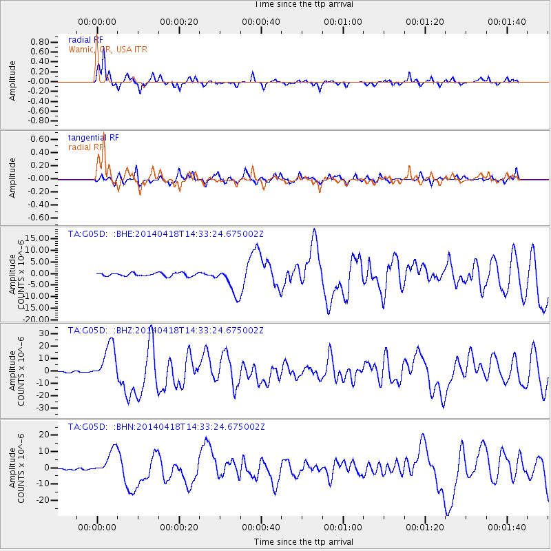
G05D Wamic, OR, USA - Earthquake Result Viewer
*The percent match for this event was below the threshold and hence no stack was calculated.
| Earthquake location: |
Guerrero, Mexico |
| Earthquake latitude/longitude: |
17.6/-100.8 |
| Earthquake time(UTC): |
2014/04/18 (108) 14:27:26 GMT |
| Earthquake Depth: |
24 km |
| Earthquake Magnitude: |
7.2 MWW, 7.0 MWB, 7.3 MWC, 7.5 MI |
| Earthquake Catalog/Contributor: |
NEIC PDE/NEIC COMCAT |
|
| Network: |
TA USArray Transportable Network (new EarthScope stations) |
| Station: |
G05D Wamic, OR, USA |
| Lat/Lon: |
45.24 N/121.32 W |
| Elevation: |
592 m |
|
| Distance: |
32.5 deg |
| Az: |
332.575 deg |
| Baz: |
141.541 deg |
| Ray Param: |
$rayparam |
*The percent match for this event was below the threshold and hence was not used in the summary stack. |
|
| Radial Match: |
83.450905 % |
| Radial Bump: |
280 |
| Transverse Match: |
70.245026 % |
| Transverse Bump: |
362 |
| SOD ConfigId: |
626651 |
| Insert Time: |
2014-05-02 15:04:28.949 +0000 |
| GWidth: |
2.5 |
| Max Bumps: |
400 |
| Tol: |
0.001 |
|
Signal To Noise
| Channel | StoN | STA | LTA |
| TA:G05D: :BHZ:20140418T14:33:24.675002Z | 31.799776 | 1.5648115E-5 | 4.9208256E-7 |
| TA:G05D: :BHN:20140418T14:33:24.675002Z | 18.802946 | 8.235697E-6 | 4.3800034E-7 |
| TA:G05D: :BHE:20140418T14:33:24.675002Z | 8.792784 | 6.229232E-6 | 7.084483E-7 |
| Arrivals |
| Ps | |
| PpPs | |
| PsPs/PpSs | |


