You are here: Home > Network List > TA - USArray Transportable Network (new EarthScope stations) Stations List
> Station G57A Newington, ON, CAN > Earthquake Result Viewer
G57A Newington, ON, CAN - Earthquake Result Viewer
| Earthquake location: |
Guerrero, Mexico |
| Earthquake latitude/longitude: |
17.6/-100.8 |
| Earthquake time(UTC): |
2014/04/18 (108) 14:27:26 GMT |
| Earthquake Depth: |
24 km |
| Earthquake Magnitude: |
7.2 MWW, 7.0 MWB, 7.3 MWC, 7.5 MI |
| Earthquake Catalog/Contributor: |
NEIC PDE/NEIC COMCAT |
|
| Network: |
TA USArray Transportable Network (new EarthScope stations) |
| Station: |
G57A Newington, ON, CAN |
| Lat/Lon: |
45.10 N/74.99 W |
| Elevation: |
96 m |
|
| Distance: |
34.9 deg |
| Az: |
32.601 deg |
| Baz: |
226.535 deg |
| Ray Param: |
0.077447616 |
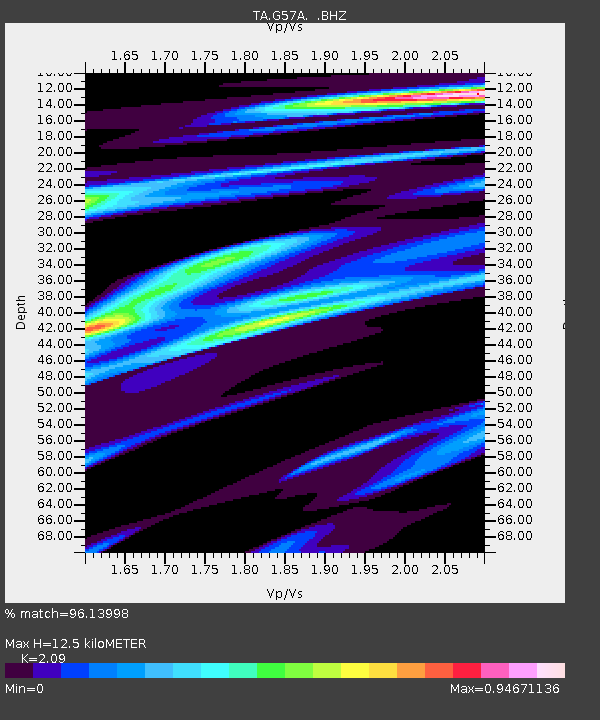
| Estimated Moho Depth: |
12.5 km |
| Estimated Crust Vp/Vs: |
2.09 |
| Assumed Crust Vp: |
6.419 km/s |
| Estimated Crust Vs: |
3.071 km/s |
| Estimated Crust Poisson's Ratio: |
0.35 |
|
| Radial Match: |
96.13998 % |
| Radial Bump: |
255 |
| Transverse Match: |
84.83518 % |
| Transverse Bump: |
400 |
| SOD ConfigId: |
626651 |
| Insert Time: |
2014-05-02 15:04:55.354 +0000 |
| GWidth: |
2.5 |
| Max Bumps: |
400 |
| Tol: |
0.001 |
|
Signal To Noise
| Channel | StoN | STA | LTA |
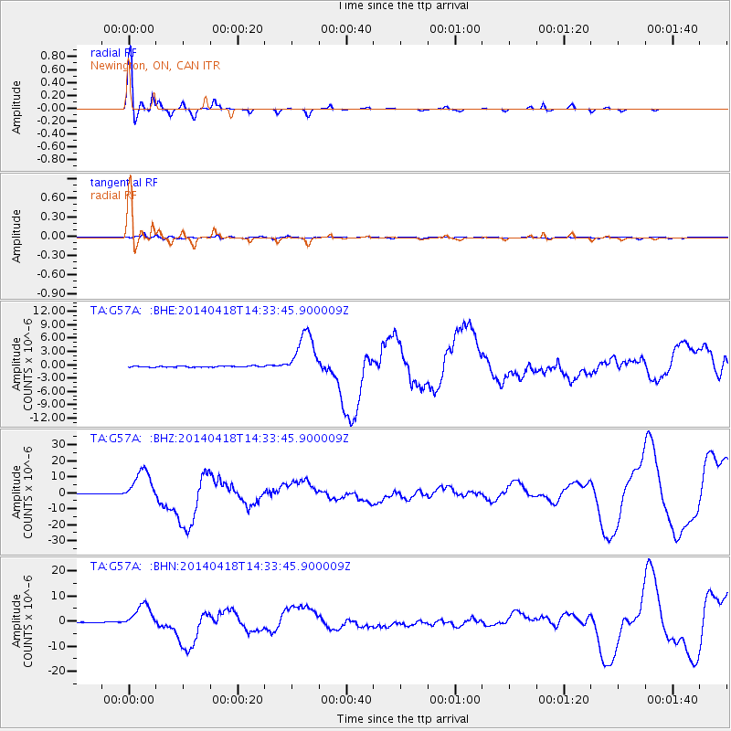
| TA:G57A: :BHZ:20140418T14:33:45.900009Z | 61.222515 | 1.0226839E-5 | 1.6704374E-7 |
| TA:G57A: :BHN:20140418T14:33:45.900009Z | 54.517487 | 4.8644474E-6 | 8.9227285E-8 |
| TA:G57A: :BHE:20140418T14:33:45.900009Z | 40.370716 | 5.1773263E-6 | 1.2824461E-7 |
| Arrivals |
| Ps | 2.3 SECOND |
| PpPs | 5.6 SECOND |
| PsPs/PpSs | 7.9 SECOND |


