You are here: Home > Network List > TA - USArray Transportable Network (new EarthScope stations) Stations List
> Station H47A Mio, MI, USA > Earthquake Result Viewer
H47A Mio, MI, USA - Earthquake Result Viewer
| Earthquake location: |
Guerrero, Mexico |
| Earthquake latitude/longitude: |
17.6/-100.8 |
| Earthquake time(UTC): |
2014/04/18 (108) 14:27:26 GMT |
| Earthquake Depth: |
24 km |
| Earthquake Magnitude: |
7.2 MWW, 7.0 MWB, 7.3 MWC, 7.5 MI |
| Earthquake Catalog/Contributor: |
NEIC PDE/NEIC COMCAT |
|
| Network: |
TA USArray Transportable Network (new EarthScope stations) |
| Station: |
H47A Mio, MI, USA |
| Lat/Lon: |
44.60 N/84.21 W |
| Elevation: |
356 m |
|
| Distance: |
30.4 deg |
| Az: |
23.828 deg |
| Baz: |
212.65 deg |
| Ray Param: |
0.07933378 |
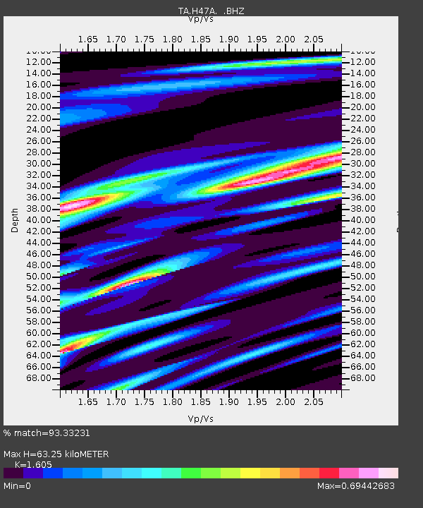
| Estimated Moho Depth: |
63.25 km |
| Estimated Crust Vp/Vs: |
1.61 |
| Assumed Crust Vp: |
6.483 km/s |
| Estimated Crust Vs: |
4.039 km/s |
| Estimated Crust Poisson's Ratio: |
0.18 |
|
| Radial Match: |
93.33231 % |
| Radial Bump: |
400 |
| Transverse Match: |
60.311443 % |
| Transverse Bump: |
400 |
| SOD ConfigId: |
626651 |
| Insert Time: |
2014-05-02 15:05:30.401 +0000 |
| GWidth: |
2.5 |
| Max Bumps: |
400 |
| Tol: |
0.001 |
|
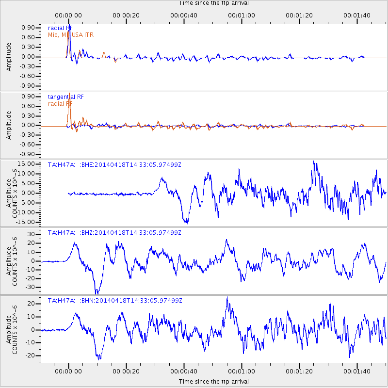
Signal To Noise
| Channel | StoN | STA | LTA |
| TA:H47A: :BHZ:20140418T14:33:05.97499Z | 51.32613 | 1.1917132E-5 | 2.321845E-7 |
| TA:H47A: :BHN:20140418T14:33:05.97499Z | 23.163977 | 7.5361727E-6 | 3.2534018E-7 |
| TA:H47A: :BHE:20140418T14:33:05.97499Z | 16.316347 | 4.6196096E-6 | 2.831277E-7 |
| Arrivals |
| Ps | 6.5 SECOND |
| PpPs | 23 SECOND |
| PsPs/PpSs | 30 SECOND |


