You are here: Home > Network List > TA - USArray Transportable Network (new EarthScope stations) Stations List
> Station H58A Gabriels, NY, USA > Earthquake Result Viewer
H58A Gabriels, NY, USA - Earthquake Result Viewer
| Earthquake location: |
Guerrero, Mexico |
| Earthquake latitude/longitude: |
17.6/-100.8 |
| Earthquake time(UTC): |
2014/04/18 (108) 14:27:26 GMT |
| Earthquake Depth: |
24 km |
| Earthquake Magnitude: |
7.2 MWW, 7.0 MWB, 7.3 MWC, 7.5 MI |
| Earthquake Catalog/Contributor: |
NEIC PDE/NEIC COMCAT |
|
| Network: |
TA USArray Transportable Network (new EarthScope stations) |
| Station: |
H58A Gabriels, NY, USA |
| Lat/Lon: |
44.42 N/74.18 W |
| Elevation: |
537 m |
|
| Distance: |
34.9 deg |
| Az: |
34.161 deg |
| Baz: |
228.38 deg |
| Ray Param: |
0.077468745 |
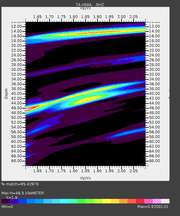
| Estimated Moho Depth: |
46.5 km |
| Estimated Crust Vp/Vs: |
1.60 |
| Assumed Crust Vp: |
6.419 km/s |
| Estimated Crust Vs: |
4.012 km/s |
| Estimated Crust Poisson's Ratio: |
0.18 |
|
| Radial Match: |
95.42978 % |
| Radial Bump: |
290 |
| Transverse Match: |
85.71758 % |
| Transverse Bump: |
311 |
| SOD ConfigId: |
626651 |
| Insert Time: |
2014-05-02 15:05:51.263 +0000 |
| GWidth: |
2.5 |
| Max Bumps: |
400 |
| Tol: |
0.001 |
|

Signal To Noise
| Channel | StoN | STA | LTA |
| TA:H58A: :BHZ:20140418T14:33:45.550002Z | 58.041767 | 1.0360249E-5 | 1.7849645E-7 |
| TA:H58A: :BHN:20140418T14:33:45.550002Z | 49.966255 | 4.861815E-6 | 9.7301964E-8 |
| TA:H58A: :BHE:20140418T14:33:45.550002Z | 35.82624 | 5.2616037E-6 | 1.4686452E-7 |
| Arrivals |
| Ps | 4.7 SECOND |
| PpPs | 17 SECOND |
| PsPs/PpSs | 22 SECOND |


