You are here: Home > Network List > CI - Caltech Regional Seismic Network Stations List
> Station BAK BAK, Bakersfield, CA, USA > Earthquake Result Viewer
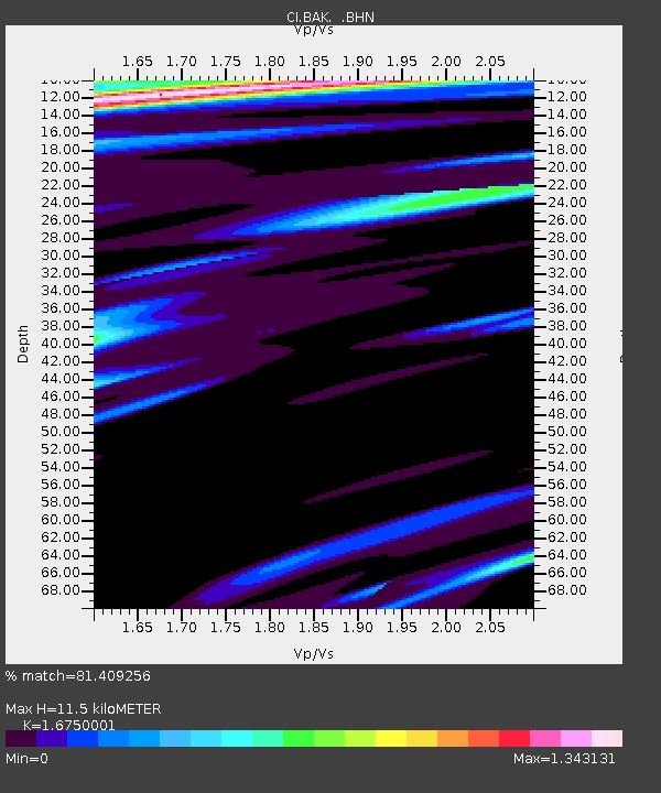
BAK BAK, Bakersfield, CA, USA - Earthquake Result Viewer
| Earthquake location: |
East Of Kuril Islands |
| Earthquake latitude/longitude: |
46.9/155.2 |
| Earthquake time(UTC): |
2009/01/15 (015) 17:49:39 GMT |
| Earthquake Depth: |
36 km |
| Earthquake Magnitude: |
6.9 MB, 7.5 MS, 7.4 MW, 7.4 MW |
| Earthquake Catalog/Contributor: |
WHDF/NEIC |
|
| Network: |
CI Caltech Regional Seismic Network |
| Station: |
BAK BAK, Bakersfield, CA, USA |
| Lat/Lon: |
35.34 N/119.10 W |
| Elevation: |
116 m |
|
| Distance: |
62.6 deg |
| Az: |
66.702 deg |
| Baz: |
309.556 deg |
| Ray Param: |
0.060071692 |
| Estimated Moho Depth: |
11.5 km |
| Estimated Crust Vp/Vs: |
1.68 |
| Assumed Crust Vp: |
6.1 km/s |
| Estimated Crust Vs: |
3.642 km/s |
| Estimated Crust Poisson's Ratio: |
0.22 |
|
| Radial Match: |
81.409256 % |
| Radial Bump: |
400 |
| Transverse Match: |
74.96815 % |
| Transverse Bump: |
400 |
| SOD ConfigId: |
2834 |
| Insert Time: |
2010-02-25 21:01:29.826 +0000 |
| GWidth: |
2.5 |
| Max Bumps: |
400 |
| Tol: |
0.001 |
|

Signal To Noise
| Channel | StoN | STA | LTA |
| CI:BAK: :BHN:20090115T17:59:28.71801Z | 8.369866 | 1.27436915E-5 | 1.5225681E-6 |
| CI:BAK: :BHE:20090115T17:59:28.71801Z | 3.0863698 | 4.7815106E-6 | 1.5492344E-6 |
| CI:BAK: :BHZ:20090115T17:59:28.720024Z | 3.7208998 | 5.984137E-6 | 1.60825E-6 |
| Arrivals |
| Ps | 1.3 SECOND |
| PpPs | 4.8 SECOND |
| PsPs/PpSs | 6.2 SECOND |


