You are here: Home > Network List > TA - USArray Transportable Network (new EarthScope stations) Stations List
> Station I04A Tendick Farm, Oakridge, OR, USA > Earthquake Result Viewer
I04A Tendick Farm, Oakridge, OR, USA - Earthquake Result Viewer
| Earthquake location: |
Guerrero, Mexico |
| Earthquake latitude/longitude: |
17.6/-100.8 |
| Earthquake time(UTC): |
2014/04/18 (108) 14:27:26 GMT |
| Earthquake Depth: |
24 km |
| Earthquake Magnitude: |
7.2 MWW, 7.0 MWB, 7.3 MWC, 7.5 MI |
| Earthquake Catalog/Contributor: |
NEIC PDE/NEIC COMCAT |
|
| Network: |
TA USArray Transportable Network (new EarthScope stations) |
| Station: |
I04A Tendick Farm, Oakridge, OR, USA |
| Lat/Lon: |
43.79 N/122.41 W |
| Elevation: |
731 m |
|
| Distance: |
31.9 deg |
| Az: |
329.701 deg |
| Baz: |
138.344 deg |
| Ray Param: |
0.07885607 |
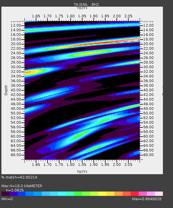
| Estimated Moho Depth: |
18.0 km |
| Estimated Crust Vp/Vs: |
2.09 |
| Assumed Crust Vp: |
6.522 km/s |
| Estimated Crust Vs: |
3.117 km/s |
| Estimated Crust Poisson's Ratio: |
0.35 |
|
| Radial Match: |
92.80218 % |
| Radial Bump: |
266 |
| Transverse Match: |
73.14839 % |
| Transverse Bump: |
400 |
| SOD ConfigId: |
626651 |
| Insert Time: |
2014-05-02 15:06:31.310 +0000 |
| GWidth: |
2.5 |
| Max Bumps: |
400 |
| Tol: |
0.001 |
|

Signal To Noise
| Channel | StoN | STA | LTA |
| TA:I04A: :BHZ:20140418T14:33:19.400009Z | 39.0491 | 1.2554895E-5 | 3.215156E-7 |
| TA:I04A: :BHN:20140418T14:33:19.400009Z | 24.577335 | 5.855825E-6 | 2.3826118E-7 |
| TA:I04A: :BHE:20140418T14:33:19.400009Z | 17.443432 | 4.6305217E-6 | 2.654593E-7 |
| Arrivals |
| Ps | 3.2 SECOND |
| PpPs | 8.0 SECOND |
| PsPs/PpSs | 11 SECOND |


