You are here: Home > Network List > TA - USArray Transportable Network (new EarthScope stations) Stations List
> Station I64A Boothbay, ME, USA > Earthquake Result Viewer
I64A Boothbay, ME, USA - Earthquake Result Viewer
| Earthquake location: |
Guerrero, Mexico |
| Earthquake latitude/longitude: |
17.6/-100.8 |
| Earthquake time(UTC): |
2014/04/18 (108) 14:27:26 GMT |
| Earthquake Depth: |
24 km |
| Earthquake Magnitude: |
7.2 MWW, 7.0 MWB, 7.3 MWC, 7.5 MI |
| Earthquake Catalog/Contributor: |
NEIC PDE/NEIC COMCAT |
|
| Network: |
TA USArray Transportable Network (new EarthScope stations) |
| Station: |
I64A Boothbay, ME, USA |
| Lat/Lon: |
43.92 N/69.63 W |
| Elevation: |
17 m |
|
| Distance: |
37.2 deg |
| Az: |
38.277 deg |
| Baz: |
234.866 deg |
| Ray Param: |
0.076254204 |
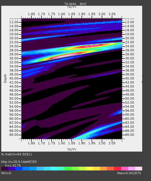
| Estimated Moho Depth: |
28.5 km |
| Estimated Crust Vp/Vs: |
1.82 |
| Assumed Crust Vp: |
6.419 km/s |
| Estimated Crust Vs: |
3.532 km/s |
| Estimated Crust Poisson's Ratio: |
0.28 |
|
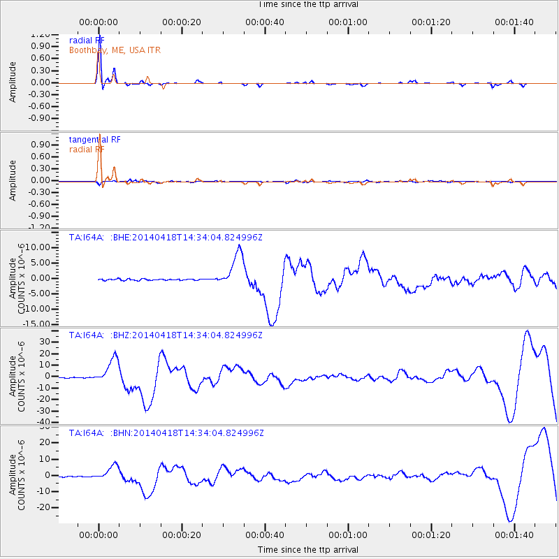
| Radial Match: |
94.50511 % |
| Radial Bump: |
213 |
| Transverse Match: |
81.780624 % |
| Transverse Bump: |
400 |
| SOD ConfigId: |
626651 |
| Insert Time: |
2014-05-02 15:07:21.000 +0000 |
| GWidth: |
2.5 |
| Max Bumps: |
400 |
| Tol: |
0.001 |
|
Signal To Noise
| Channel | StoN | STA | LTA |
| TA:I64A: :BHZ:20140418T14:34:04.824996Z | 29.874569 | 1.1628433E-5 | 3.8924185E-7 |
| TA:I64A: :BHN:20140418T14:34:04.824996Z | 13.564379 | 4.796077E-6 | 3.5357883E-7 |
| TA:I64A: :BHE:20140418T14:34:04.824996Z | 27.280571 | 5.911205E-6 | 2.1668185E-7 |
| Arrivals |
| Ps | 3.9 SECOND |
| PpPs | 12 SECOND |
| PsPs/PpSs | 16 SECOND |


