You are here: Home > Network List > TA - USArray Transportable Network (new EarthScope stations) Stations List
> Station J05D Fort Rock, OR, USA > Earthquake Result Viewer
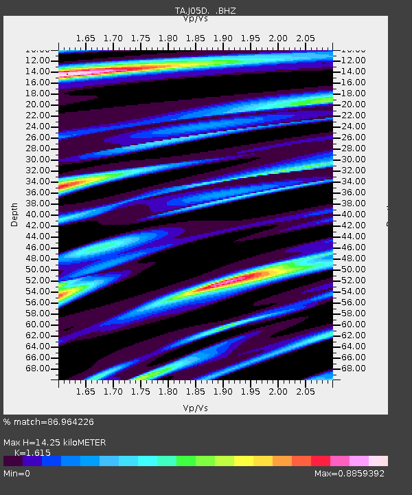
J05D Fort Rock, OR, USA - Earthquake Result Viewer
| Earthquake location: |
Guerrero, Mexico |
| Earthquake latitude/longitude: |
17.6/-100.8 |
| Earthquake time(UTC): |
2014/04/18 (108) 14:27:26 GMT |
| Earthquake Depth: |
24 km |
| Earthquake Magnitude: |
7.2 MWW, 7.0 MWB, 7.3 MWC, 7.5 MI |
| Earthquake Catalog/Contributor: |
NEIC PDE/NEIC COMCAT |
|
| Network: |
TA USArray Transportable Network (new EarthScope stations) |
| Station: |
J05D Fort Rock, OR, USA |
| Lat/Lon: |
43.28 N/121.23 W |
| Elevation: |
1541 m |
|
| Distance: |
30.9 deg |
| Az: |
330.299 deg |
| Baz: |
139.662 deg |
| Ray Param: |
0.079181194 |
| Estimated Moho Depth: |
14.25 km |
| Estimated Crust Vp/Vs: |
1.62 |
| Assumed Crust Vp: |
6.597 km/s |
| Estimated Crust Vs: |
4.085 km/s |
| Estimated Crust Poisson's Ratio: |
0.19 |
|
| Radial Match: |
86.964226 % |
| Radial Bump: |
400 |
| Transverse Match: |
72.60483 % |
| Transverse Bump: |
400 |
| SOD ConfigId: |
626651 |
| Insert Time: |
2014-05-02 15:07:34.995 +0000 |
| GWidth: |
2.5 |
| Max Bumps: |
400 |
| Tol: |
0.001 |
|

Signal To Noise
| Channel | StoN | STA | LTA |
| TA:J05D: :BHZ:20140418T14:33:11.09999Z | 52.495277 | 1.3602725E-5 | 2.5912283E-7 |
| TA:J05D: :BHN:20140418T14:33:11.09999Z | 16.64008 | 6.58039E-6 | 3.9545426E-7 |
| TA:J05D: :BHE:20140418T14:33:11.09999Z | 20.906492 | 5.7884527E-6 | 2.7687346E-7 |
| Arrivals |
| Ps | 1.5 SECOND |
| PpPs | 5.1 SECOND |
| PsPs/PpSs | 6.6 SECOND |


