You are here: Home > Network List > TA - USArray Transportable Network (new EarthScope stations) Stations List
> Station K63A Dunstable, MA, USA > Earthquake Result Viewer
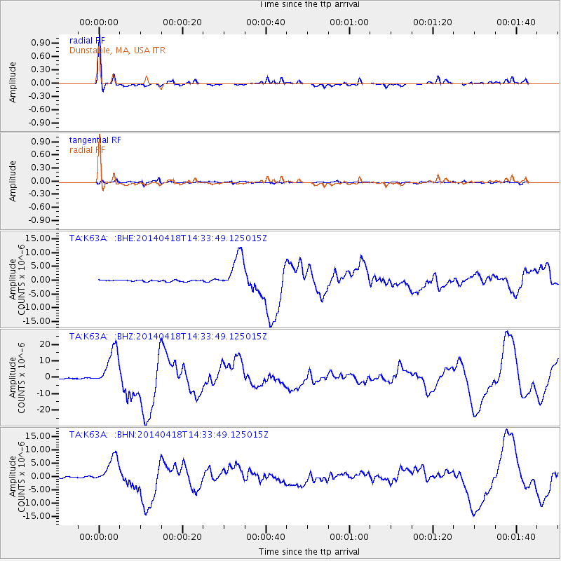
K63A Dunstable, MA, USA - Earthquake Result Viewer

| Earthquake location: |
Guerrero, Mexico |
| Earthquake latitude/longitude: |
17.6/-100.8 |
| Earthquake time(UTC): |
2014/04/18 (108) 14:27:26 GMT |
| Earthquake Depth: |
24 km |
| Earthquake Magnitude: |
7.2 MWW, 7.0 MWB, 7.3 MWC, 7.5 MI |
| Earthquake Catalog/Contributor: |
NEIC PDE/NEIC COMCAT |
|
| Network: |
TA USArray Transportable Network (new EarthScope stations) |
| Station: |
K63A Dunstable, MA, USA |
| Lat/Lon: |
42.69 N/71.53 W |
| Elevation: |
68 m |
|
| Distance: |
35.3 deg |
| Az: |
38.605 deg |
| Baz: |
233.837 deg |
| Ray Param: |
0.077253826 |
| Estimated Moho Depth: |
23.0 km |
| Estimated Crust Vp/Vs: |
1.97 |
| Assumed Crust Vp: |
6.419 km/s |
| Estimated Crust Vs: |
3.263 km/s |
| Estimated Crust Poisson's Ratio: |
0.33 |
|
| Radial Match: |
91.73382 % |
| Radial Bump: |
291 |
| Transverse Match: |
69.5409 % |
| Transverse Bump: |
400 |
| SOD ConfigId: |
626651 |
| Insert Time: |
2014-05-02 15:08:59.881 +0000 |
| GWidth: |
2.5 |
| Max Bumps: |
400 |
| Tol: |
0.001 |
|
Signal To Noise
| Channel | StoN | STA | LTA |
| TA:K63A: :BHZ:20140418T14:33:49.125015Z | 43.382652 | 1.21368275E-5 | 2.7976222E-7 |
| TA:K63A: :BHN:20140418T14:33:49.125015Z | 22.857325 | 5.1754364E-6 | 2.2642354E-7 |
| TA:K63A: :BHE:20140418T14:33:49.125015Z | 26.231411 | 6.687903E-6 | 2.549578E-7 |
| Arrivals |
| Ps | 3.7 SECOND |
| PpPs | 9.9 SECOND |
| PsPs/PpSs | 14 SECOND |


