You are here: Home > Network List > II - Global Seismograph Network (GSN - IRIS/IDA) Stations List
> Station KDAK Kodiak Island, Alaska, USA > Earthquake Result Viewer
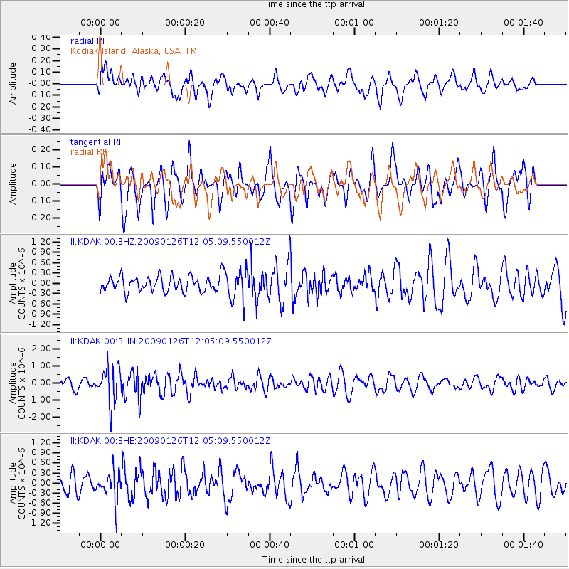
KDAK Kodiak Island, Alaska, USA - Earthquake Result Viewer
*The percent match for this event was below the threshold and hence no stack was calculated.
| Earthquake location: |
Fiji Islands Region |
| Earthquake latitude/longitude: |
-17.8/-178.6 |
| Earthquake time(UTC): |
2009/01/26 (026) 11:54:39 GMT |
| Earthquake Depth: |
580 km |
| Earthquake Magnitude: |
5.5 MB, 5.8 MW, 5.8 MW |
| Earthquake Catalog/Contributor: |
WHDF/NEIC |
|
| Network: |
II Global Seismograph Network (GSN - IRIS/IDA) |
| Station: |
KDAK Kodiak Island, Alaska, USA |
| Lat/Lon: |
57.78 N/152.58 W |
| Elevation: |
152 m |
|
| Distance: |
78.3 deg |
| Az: |
13.878 deg |
| Baz: |
205.251 deg |
| Ray Param: |
$rayparam |
*The percent match for this event was below the threshold and hence was not used in the summary stack. |
|
| Radial Match: |
58.16279 % |
| Radial Bump: |
400 |
| Transverse Match: |
63.6694 % |
| Transverse Bump: |
400 |
| SOD ConfigId: |
2658 |
| Insert Time: |
2010-03-01 21:15:12.829 +0000 |
| GWidth: |
2.5 |
| Max Bumps: |
400 |
| Tol: |
0.001 |
|
Signal To Noise
| Channel | StoN | STA | LTA |
| II:KDAK:00:BHN:20090126T12:05:09.550012Z | 2.6350656 | 1.0506868E-6 | 3.9873274E-7 |
| II:KDAK:00:BHE:20090126T12:05:09.550012Z | 1.3393086 | 4.324991E-7 | 3.2292715E-7 |
| II:KDAK:00:BHZ:20090126T12:05:09.550012Z | 2.1424742 | 4.496202E-7 | 2.0986027E-7 |
| Arrivals |
| Ps | |
| PpPs | |
| PsPs/PpSs | |


